Le Pian-sur-Garonne geodata
Le Pian-sur-Garonne (Nouvelle-Aquitaine) is a populated place; located in France in Europe/Paris (GMT+2) time zone. With population of 657 people, there are 12427 cities with bigger population in this country. Compared to other cities in France, 82.9% of cities are located further ↑North; 79.8% of cities are located further →East and 60% of cities have higher elevation than Le Pian-sur-Garonne. Note1
Administrative division(s):
- Level 1: Nouvelle-Aquitaine
- Level 2: Gironde
- Level 3: Arrondissement de Langon
- Level 4: Le Pian-sur-Garonne


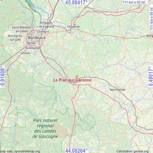
Le Pian-sur-Garonne GPS coordinates[2]
44° 35' 8.016" North, 0° 12' 46.62" West
| Map corner | latitude | longitude |
|---|---|---|
| Upper-left | 45.08417°, | -0.91608° |
| Center: | 44.58556°, | -0.21295° |
| Lower-right: | 44.08264°, | 0.49017° |
| Map W x H: | 111.4×111.4 km | = 69.2×69.2mi |
| max Lat: | 51.07786° ⇑82.9% North |
| Le Pian-sur-Garonne: | 44.58556° |
| min Lat: | ⇓17.1% South 41.3874° |
| min Long | Le Pian-sur-Gar | max Long |
| -5.08615° | -0.21295° | 9.52242° |
| W 20.2%⇐ | ⇒79.8% E |
Elevation
Elevation of Le Pian-sur-Garonne is 102 m = 335 ft, and this is 91.7 m = 301 ft below average elevation for this country.
| Max E: |
2333 m = 7654 ft | 60% |
| Avg. | 193.7 m = 635 ft | |
| Le Pian-sur-Garonne | 102 m = 335 ft | |
Min E: |
-1 m = -3 ft | 40% |
See also: France elevation on elevation.city.
Geographical zone
Le Pian-sur-Garonne is located in North temperate zone (between Tropic of Cancer and the Arctic Circle). Distance of this Northern Tropic circle is 2351.5 km =1461.2 mi to South.| Distance of | km | miles | from Le Pian-sur-Garonne |
|---|---|---|---|
| North Pole | 5049.6 | 3137.7 | to North |
| Arctic Circle | 2443.7 | 1518.4 | to North |
| Tropic Cancer | 2351.5 | 1461.2 | to South |
| Equator | 4957.4 | 3080.4 | to South |


Nearby cities:
15 places around Le Pian-sur-Garonne: (largest is in red/bold)
• Barsac
8.5 km =5.3 mi,  286°
286°
• Cadillac
10 km =6.2 mi,  304°
304°
• Castets-en-Dorthe
5.5 km =3.4 mi,  119°
119°
• Caudrot
5.6 km =3.5 mi,  101°
101°
• Coimères
9.9 km =6.2 mi,  177°
177°
• Langon
4.6 km =2.9 mi,  218°
218°
• Loupiac
7.7 km =4.8 mi, 296°
• Preignac
6.4 km =4 mi,  268°
268°
• Saint-Macaire
2.4 km =1.5 mi,  201°
201°
• Saint-Maixant
3.7 km =2.3 mi,  258°
258°
• Saint-Martin-de-Sescas
4.2 km =2.6 mi,  105°
105°
• Saint-Pierre-d’Aurillac
2.4 km =1.5 mi,  129°
129°
• Sainte-Croix-du-Mont
4.8 km =3 mi,  281°
281°
• Toulenne
5.1 km =3.2 mi,  231°
231°
• Verdelais
2.9 km =1.8 mi, 276°
Sources, notices
• [Note1] Compared only with cities in France existing in our database
• [Src1] Map data: © OpenStreetMap contributors (CC-BY-SA)
• [Src2] Other city data from geonames.org with taken over terms of usage.
• [Src3] Geographical zone / Annual Mean Temperature by Robert A. Rohde @ Wikipedia
