Équihen-Plage geodata
Équihen-Plage (Hauts-de-France) is a populated place; located in France in Europe/Paris (GMT+2) time zone. With population of 2,986 people, there are 3267 cities with bigger population in this country. Compared to other cities in France, 98.6% of cities are located further ↓South; 62.1% of cities are located further →East and 73.6% of cities have higher elevation than Équihen-Plage. Note1
Administrative division(s):
- Level 1: Hauts-de-France
- Level 2: Pas-de-Calais
- Level 3: Arrondissement de Boulogne-sur-Mer
- Level 4: Équihen-Plage


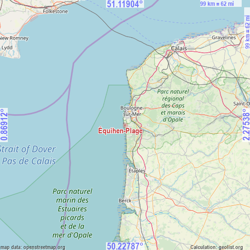
Équihen-Plage GPS coordinates[2]
50° 40' 32.052" North, 1° 34' 20.1" East
| Map corner | latitude | longitude |
|---|---|---|
| Upper-left | 51.11904°, | 0.86912° |
| Center: | 50.67557°, | 1.57225° |
| Lower-right: | 50.22787°, | 2.27538° |
| Map W x H: | 99.1×99.1 km | = 61.6×61.6mi |
| max Lat: | 51.07786° ⇑1.4% North |
| Équihen-Plage: | 50.67557° |
| min Lat: | ⇓98.6% South 41.3874° |
| min Long | Équihen-Plage | max Long |
| -5.08615° | 1.57225° | 9.52242° |
| W 37.9%⇐ | ⇒62.1% E |
Elevation
Elevation of Équihen-Plage is 70 m = 230 ft, and this is 123.7 m = 406 ft below average elevation for this country.
| Max E: |
2333 m = 7654 ft | 73.6% |
| Avg. | 193.7 m = 635 ft | |
| Équihen-Plage | 70 m = 230 ft | |
Min E: |
-1 m = -3 ft | 26.4% |
See also: France elevation on elevation.city.
Geographical zone
Équihen-Plage is located in North temperate zone (between Tropic of Cancer and the Arctic Circle). Distance of this North polar circle is 1766.6 km =1097.7 mi to North.| Distance of | km | miles | from Équihen-Plage |
|---|---|---|---|
| North Pole | 4372.5 | 2716.9 | to North |
| Arctic Circle | 1766.6 | 1097.7 | to North |
| Tropic Cancer | 3028.7 | 1881.9 | to South |
| Equator | 5634.6 | 3501.2 | to South |


Nearby cities:
15 places around Équihen-Plage: (largest is in red/bold)
• Baincthun
8.5 km =5.3 mi,  63°
63°
• Boulogne-sur-Mer
6.3 km =3.9 mi,  27°
27°
• Carly
9.6 km =6 mi,  106°
106°
• Condette
4.8 km =3 mi, 114°
• Dannes
10.2 km =6.3 mi,  163°
163°
• Hesdigneul-lès-Boulogne
6.5 km =4 mi,  104°
104°
• Isques
5.8 km =3.6 mi,  91°
91°
• Le Portel
3.3 km =2.1 mi,  4°
4°
• Nesles
8.1 km =5 mi,  132°
132°
• Neufchâtel-Hardelot
7.9 km =4.9 mi,  141°
141°
• Outreau
3.5 km =2.2 mi,  20°
20°
• Saint-Léonard
4.1 km =2.5 mi,  65°
65°
• Saint-Martin-Boulogne
6.6 km =4.1 mi, 29°
• Saint-Étienne-au-Mont
4.1 km =2.5 mi, 86°
• Wimille
10.7 km =6.6 mi, 22°
Sources, notices
• [Note1] Compared only with cities in France existing in our database
• [Src1] Map data: © OpenStreetMap contributors (CC-BY-SA)
• [Src2] Other city data from geonames.org with taken over terms of usage.
• [Src3] Geographical zone / Annual Mean Temperature by Robert A. Rohde @ Wikipedia
