Saint-Martin-au-Laërt geodata
Saint-Martin-au-Laërt (Hauts-de-France) is a populated place; located in France in Europe/Paris (GMT+2) time zone. With population of 3,881 people, there are 2533 cities with bigger population in this country. Compared to other cities in France, 99.1% of cities are located further ↓South; 53.7% of cities are located further →East and 96.7% of cities have higher elevation than Saint-Martin-au-Laërt. Note1
Administrative division(s):
- Level 1: Hauts-de-France
- Level 2: Pas-de-Calais
- Level 3: Arrondissement de Saint-Omer
- Level 4: Saint-Martin-lez-Tatinghem


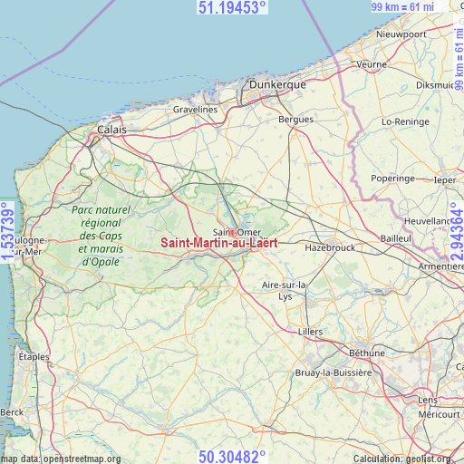
Saint-Martin-au-Laërt GPS coordinates[2]
50° 45' 6.444" North, 2° 14' 25.836" East
| Map corner | latitude | longitude |
|---|---|---|
| Upper-left | 51.19453°, | 1.53739° |
| Center: | 50.75179°, | 2.24051° |
| Lower-right: | 50.30482°, | 2.94364° |
| Map W x H: | 98.9×98.9 km | = 61.5×61.5mi |
| max Lat: | 51.07786° ⇑0.9% North |
| Saint-Martin-au-Laërt: | 50.75179° |
| min Lat: | ⇓99.1% South 41.3874° |
| min Long | Saint-Martin-au | max Long |
| -5.08615° | 2.24051° | 9.52242° |
| W 46.3%⇐ | ⇒53.7% E |
Elevation
Elevation of Saint-Martin-au-Laërt is 12 m = 39 ft, and this is 181.7 m = 596 ft below average elevation for this country.
| Max E: |
2333 m = 7654 ft | 96.7% |
| Avg. | 193.7 m = 635 ft | |
| Saint-Martin-au-Laërt | 12 m = 39 ft | |
Min E: |
-1 m = -3 ft | 3.3% |
See also: France elevation on elevation.city.
Geographical zone
Saint-Martin-au-Laërt is located in North temperate zone (between Tropic of Cancer and the Arctic Circle). Distance of this North polar circle is 1758.1 km =1092.4 mi to North.| Distance of | km | miles | from Saint-Martin-au-Laërt |
|---|---|---|---|
| North Pole | 4364 | 2711.7 | to North |
| Arctic Circle | 1758.1 | 1092.4 | to North |
| Tropic Cancer | 3037.2 | 1887.2 | to South |
| Equator | 5643.1 | 3506.5 | to South |


Nearby cities:
15 places around Saint-Martin-au-Laërt: (largest is in red/bold)
• Arques
4.8 km =3 mi,  114°
114°
• Blendecques
4.9 km =3 mi,  139°
139°
• Clairmarais
4.9 km =3 mi,  59°
59°
• Esquerdes
6.4 km =4 mi,  214°
214°
• Hallines
4.7 km =2.9 mi,  192°
192°
• Helfaut
6 km =3.7 mi,  178°
178°
• Longuenesse
2 km =1.2 mi, 190°
• Moulle
6 km =3.7 mi,  312°
312°
• Nieurlet
5 km =3.1 mi,  35°
35°
• Saint-Omer
1.5 km =0.9 mi,  104°
104°
• Salperwick
2.5 km =1.6 mi,  346°
346°
• Serques
5.4 km =3.4 mi,  329°
329°
• Tatinghem
2.5 km =1.6 mi,  247°
247°
• Tilques
4 km =2.5 mi, 314°
• Wizernes
4.5 km =2.8 mi, 177°
Sources, notices
• [Note1] Compared only with cities in France existing in our database
• [Src1] Map data: © OpenStreetMap contributors (CC-BY-SA)
• [Src2] Other city data from geonames.org with taken over terms of usage.
• [Src3] Geographical zone / Annual Mean Temperature by Robert A. Rohde @ Wikipedia
