Arques geodata
Arques (Hauts-de-France) is a populated place; located in France in Europe/Paris (GMT+2) time zone. With population of 9,551 people, there are 992 cities with bigger population in this country. Compared to other cities in France, 99% of cities are located further ↓South; 52.7% of cities are located further →East and 97.8% of cities have higher elevation than Arques. Note1
Administrative division(s):
- Level 1: Hauts-de-France
- Level 2: Pas-de-Calais
- Level 3: Arrondissement de Saint-Omer
- Level 4: Arques


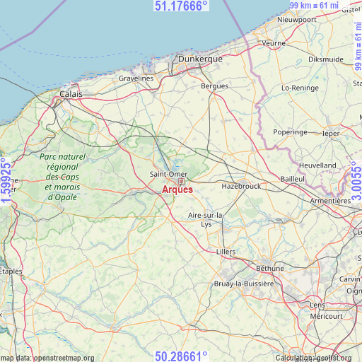
Arques GPS coordinates[2]
50° 44' 1.5" North, 2° 18' 8.532" East
| Map corner | latitude | longitude |
|---|---|---|
| Upper-left | 51.17666°, | 1.59925° |
| Center: | 50.73375°, | 2.30237° |
| Lower-right: | 50.28661°, | 3.0055° |
| Map W x H: | 99×99 km | = 61.5×61.5mi |
| max Lat: | 51.07786° ⇑1% North |
| Arques: | 50.73375° |
| min Lat: | ⇓99% South 41.3874° |
| min Long | Arques | max Long |
| -5.08615° | 2.30237° | 9.52242° |
| W 47.3%⇐ | ⇒52.7% E |
Elevation
Elevation of Arques is 9 m = 30 ft, and this is 184.7 m = 606 ft below average elevation for this country.
| Max E: |
2333 m = 7654 ft | 97.8% |
| Avg. | 193.7 m = 635 ft | |
| Arques | 9 m = 30 ft | |
Min E: |
-1 m = -3 ft | 2.2% |
See also: France elevation on elevation.city.
Geographical zone
Arques is located in North temperate zone (between Tropic of Cancer and the Arctic Circle). Distance of this North polar circle is 1760.1 km =1093.7 mi to North.| Distance of | km | miles | from Arques |
|---|---|---|---|
| North Pole | 4366 | 2712.9 | to North |
| Arctic Circle | 1760.1 | 1093.7 | to North |
| Tropic Cancer | 3035.1 | 1885.9 | to South |
| Equator | 5641.1 | 3505.2 | to South |


Nearby cities:
15 places around Arques: (largest is in red/bold)
• Blendecques
2.1 km =1.3 mi,  214°
214°
• Campagne-lès-Wardrecques
2.7 km =1.7 mi,  126°
126°
• Clairmarais
4.5 km =2.8 mi,  357°
357°
• Hallines
5.9 km =3.7 mi,  244°
244°
• Helfaut
5.8 km =3.6 mi,  226°
226°
• Heuringhem
4.4 km =2.7 mi,  197°
197°
• Longuenesse
4.7 km =2.9 mi,  270°
270°
• Nieurlet
6.2 km =3.9 mi,  347°
347°
• Quiestède
6.3 km =3.9 mi,  159°
159°
• Racquinghem
6 km =3.7 mi,  139°
139°
• Renescure
4.7 km =2.9 mi,  98°
98°
• Saint-Martin-au-Laërt
4.8 km =3 mi,  294°
294°
• Saint-Omer
3.3 km =2.1 mi,  299°
299°
• Wardrecques
3.9 km =2.4 mi, 130°
• Wizernes
4.8 km =3 mi, 239°
Sources, notices
• [Note1] Compared only with cities in France existing in our database
• [Src1] Map data: © OpenStreetMap contributors (CC-BY-SA)
• [Src2] Other city data from geonames.org with taken over terms of usage.
• [Src3] Geographical zone / Annual Mean Temperature by Robert A. Rohde @ Wikipedia
