Saint-Omer geodata
Saint-Omer (Hauts-de-France) is a seat of a third-order administrative division; located in France in Europe/Paris (GMT+2) time zone. With population of 18,250 people, there are 520 cities with bigger population in this country. Compared to other cities in France, 99.1% of cities are located further ↓South; 53.4% of cities are located further →East and 99.3% of cities have higher elevation than Saint-Omer. Note1
Administrative division(s):
- Level 1: Hauts-de-France
- Level 2: Pas-de-Calais
- Level 3: Arrondissement de Saint-Omer
- Level 4: Saint-Omer


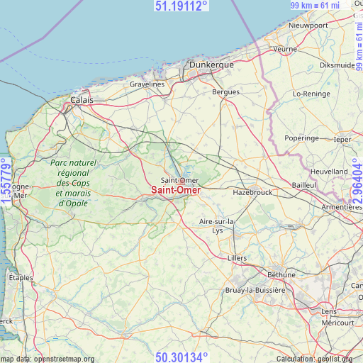
Saint-Omer GPS coordinates[2]
50° 44' 54.024" North, 2° 15' 39.276" East
| Map corner | latitude | longitude |
|---|---|---|
| Upper-left | 51.19112°, | 1.55779° |
| Center: | 50.74834°, | 2.26091° |
| Lower-right: | 50.30134°, | 2.96404° |
| Map W x H: | 98.9×98.9 km | = 61.5×61.5mi |
| max Lat: | 51.07786° ⇑0.9% North |
| Saint-Omer: | 50.74834° |
| min Lat: | ⇓99.1% South 41.3874° |
| min Long | Saint-Omer | max Long |
| -5.08615° | 2.26091° | 9.52242° |
| W 46.6%⇐ | ⇒53.4% E |
Elevation
Elevation of Saint-Omer is 5 m = 16 ft, and this is 188.7 m = 619 ft below average elevation for this country.
| Max E: |
2333 m = 7654 ft | 99.3% |
| Avg. | 193.7 m = 635 ft | |
| Saint-Omer | 5 m = 16 ft | |
Min E: |
-1 m = -3 ft | 0.7% |
See also: France elevation on elevation.city.
Geographical zone
Saint-Omer is located in North temperate zone (between Tropic of Cancer and the Arctic Circle). Distance of this North polar circle is 1758.5 km =1092.7 mi to North.| Distance of | km | miles | from Saint-Omer |
|---|---|---|---|
| North Pole | 4364.4 | 2711.9 | to North |
| Arctic Circle | 1758.5 | 1092.7 | to North |
| Tropic Cancer | 3036.8 | 1887 | to South |
| Equator | 5642.7 | 3506.2 | to South |


Nearby cities:
15 places around Saint-Omer: (largest is in red/bold)
• Arques
3.3 km =2.1 mi,  119°
119°
• Blendecques
3.8 km =2.4 mi,  152°
152°
• Campagne-lès-Wardrecques
6.1 km =3.8 mi, 122°
• Clairmarais
4 km =2.5 mi,  43°
43°
• Hallines
4.8 km =3 mi,  210°
210°
• Helfaut
5.8 km =3.6 mi,  193°
193°
• Heuringhem
6 km =3.7 mi,  164°
164°
• Longuenesse
2.4 km =1.5 mi,  228°
228°
• Nieurlet
4.7 km =2.9 mi,  18°
18°
• Saint-Martin-au-Laërt
1.5 km =0.9 mi,  284°
284°
• Salperwick
3.5 km =2.2 mi,  324°
324°
• Serques
6.5 km =4 mi, 320°
• Tatinghem
3.8 km =2.4 mi,  261°
261°
• Tilques
5.4 km =3.4 mi,  306°
306°
• Wizernes
4.3 km =2.7 mi,  197°
197°
Sources, notices
• [Note1] Compared only with cities in France existing in our database
• [Src1] Map data: © OpenStreetMap contributors (CC-BY-SA)
• [Src2] Other city data from geonames.org with taken over terms of usage.
• [Src3] Geographical zone / Annual Mean Temperature by Robert A. Rohde @ Wikipedia
