Hallines geodata
Hallines (Hauts-de-France) is a populated place; located in France in Europe/Paris (GMT+2) time zone. With population of 1,436 people, there are 6450 cities with bigger population in this country. Compared to other cities in France, 98.9% of cities are located further ↓South; 54% of cities are located further →East and 88.3% of cities have higher elevation than Hallines. Note1
Administrative division(s):
- Level 1: Hauts-de-France
- Level 2: Pas-de-Calais
- Level 3: Arrondissement de Saint-Omer
- Level 4: Hallines


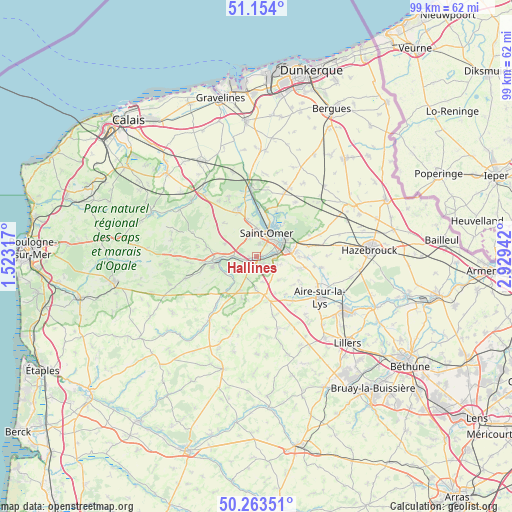
Hallines GPS coordinates[2]
50° 42' 39.132" North, 2° 13' 34.644" East
| Map corner | latitude | longitude |
|---|---|---|
| Upper-left | 51.154°, | 1.52317° |
| Center: | 50.71087°, | 2.22629° |
| Lower-right: | 50.26351°, | 2.92942° |
| Map W x H: | 99×99 km | = 61.5×61.5mi |
| max Lat: | 51.07786° ⇑1.1% North |
| Hallines: | 50.71087° |
| min Lat: | ⇓98.9% South 41.3874° |
| min Long | Hallines | max Long |
| -5.08615° | 2.22629° | 9.52242° |
| W 46%⇐ | ⇒54% E |
Elevation
Elevation of Hallines is 34 m = 112 ft, and this is 159.7 m = 524 ft below average elevation for this country.
| Max E: |
2333 m = 7654 ft | 88.3% |
| Avg. | 193.7 m = 635 ft | |
| Hallines | 34 m = 112 ft | |
Min E: |
-1 m = -3 ft | 11.7% |
See also: France elevation on elevation.city.
Geographical zone
Hallines is located in North temperate zone (between Tropic of Cancer and the Arctic Circle). Distance of this North polar circle is 1762.7 km =1095.3 mi to North.| Distance of | km | miles | from Hallines |
|---|---|---|---|
| North Pole | 4368.5 | 2714.5 | to North |
| Arctic Circle | 1762.7 | 1095.3 | to North |
| Tropic Cancer | 3032.6 | 1884.4 | to South |
| Equator | 5638.5 | 3503.6 | to South |


Nearby cities:
15 places around Hallines: (largest is in red/bold)
• Arques
5.9 km =3.7 mi,  64°
64°
• Blendecques
4.3 km =2.7 mi,  78°
78°
• Cléty
7 km =4.3 mi,  204°
204°
• Ecques
6.2 km =3.9 mi,  137°
137°
• Esquerdes
2.8 km =1.7 mi,  254°
254°
• Helfaut
1.8 km =1.1 mi, 142°
• Heuringhem
4.3 km =2.7 mi,  111°
111°
• Longuenesse
2.6 km =1.6 mi,  13°
13°
• Pihem
3.2 km =2 mi, 196°
• Saint-Martin-au-Laërt
4.7 km =2.9 mi, 12°
• Saint-Omer
4.8 km =3 mi,  30°
30°
• Salperwick
7 km =4.3 mi,  3°
3°
• Setques
4.8 km =3 mi,  270°
270°
• Tatinghem
3.8 km =2.4 mi,  339°
339°
• Wizernes
1.2 km =0.7 mi,  85°
85°
Sources, notices
• [Note1] Compared only with cities in France existing in our database
• [Src1] Map data: © OpenStreetMap contributors (CC-BY-SA)
• [Src2] Other city data from geonames.org with taken over terms of usage.
• [Src3] Geographical zone / Annual Mean Temperature by Robert A. Rohde @ Wikipedia
