Longuenesse geodata
Longuenesse (Hauts-de-France) is a populated place; located in France in Europe/Paris (GMT+2) time zone. With population of 13,838 people, there are 684 cities with bigger population in this country. Compared to other cities in France, 99% of cities are located further ↓South; 53.8% of cities are located further →East and 83.8% of cities have higher elevation than Longuenesse. Note1
Administrative division(s):
- Level 1: Hauts-de-France
- Level 2: Pas-de-Calais
- Level 3: Arrondissement de Saint-Omer
- Level 4: Longuenesse


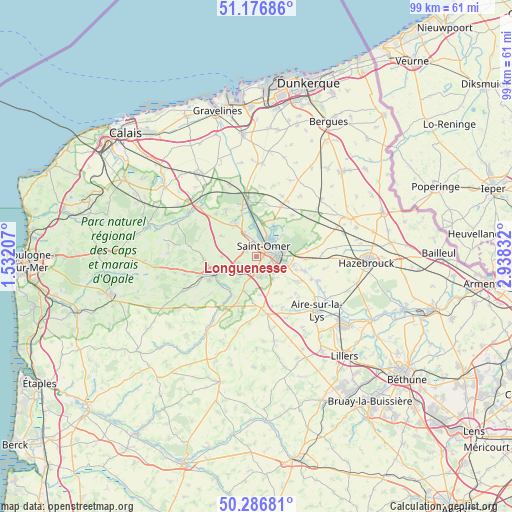
Longuenesse GPS coordinates[2]
50° 44' 2.22" North, 2° 14' 6.72" East
| Map corner | latitude | longitude |
|---|---|---|
| Upper-left | 51.17686°, | 1.53207° |
| Center: | 50.73395°, | 2.2352° |
| Lower-right: | 50.28681°, | 2.93832° |
| Map W x H: | 99×99 km | = 61.5×61.5mi |
| max Lat: | 51.07786° ⇑1% North |
| Longuenesse: | 50.73395° |
| min Lat: | ⇓99% South 41.3874° |
| min Long | Longuenesse | max Long |
| -5.08615° | 2.2352° | 9.52242° |
| W 46.2%⇐ | ⇒53.8% E |
Elevation
Elevation of Longuenesse is 45 m = 148 ft, and this is 148.7 m = 488 ft below average elevation for this country.
| Max E: |
2333 m = 7654 ft | 83.8% |
| Avg. | 193.7 m = 635 ft | |
| Longuenesse | 45 m = 148 ft | |
Min E: |
-1 m = -3 ft | 16.2% |
See also: France elevation on elevation.city.
Geographical zone
Longuenesse is located in North temperate zone (between Tropic of Cancer and the Arctic Circle). Distance of this North polar circle is 1760.1 km =1093.7 mi to North.| Distance of | km | miles | from Longuenesse |
|---|---|---|---|
| North Pole | 4366 | 2712.9 | to North |
| Arctic Circle | 1760.1 | 1093.7 | to North |
| Tropic Cancer | 3035.2 | 1886 | to South |
| Equator | 5641.1 | 3505.2 | to South |


Nearby cities:
15 places around Longuenesse: (largest is in red/bold)
• Arques
4.7 km =2.9 mi,  90°
90°
• Blendecques
4 km =2.5 mi,  115°
115°
• Clairmarais
6.4 km =4 mi,  45°
45°
• Esquerdes
4.7 km =2.9 mi,  224°
224°
• Hallines
2.6 km =1.6 mi,  193°
193°
• Helfaut
4 km =2.5 mi,  172°
172°
• Heuringhem
5.4 km =3.4 mi,  140°
140°
• Pihem
5.9 km =3.7 mi,  195°
195°
• Saint-Martin-au-Laërt
2 km =1.2 mi,  10°
10°
• Saint-Omer
2.4 km =1.5 mi, 48°
• Salperwick
4.5 km =2.8 mi,  356°
356°
• Setques
5.9 km =3.7 mi,  245°
245°
• Tatinghem
2.2 km =1.4 mi,  297°
297°
• Tilques
5.4 km =3.4 mi,  332°
332°
• Wizernes
2.5 km =1.6 mi, 167°
Sources, notices
• [Note1] Compared only with cities in France existing in our database
• [Src1] Map data: © OpenStreetMap contributors (CC-BY-SA)
• [Src2] Other city data from geonames.org with taken over terms of usage.
• [Src3] Geographical zone / Annual Mean Temperature by Robert A. Rohde @ Wikipedia
