Saint-Maclou-de-Folleville geodata
Saint-Maclou-de-Folleville (Normandy) is a populated place; located in France in Europe/Paris (GMT+2) time zone. With population of 531 people, there are 14589 cities with bigger population in this country. Compared to other cities in France, 91.4% of cities are located further ↓South; 67.8% of cities are located further →East and 53.8% of cities have higher elevation than Saint-Maclou-de-Folleville. Note1
Administrative division(s):
- Level 1: Normandy
- Level 2: Seine-Maritime
- Level 3: Arrondissement de Dieppe
- Level 4: Saint-Maclou-de-Folleville
Current local time in Saint-Maclou-de-Folleville:
08:37 AM, SaturdayDifference from your time zone: hours


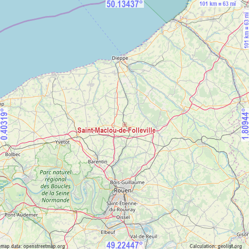
Saint-Maclou-de-Folleville GPS coordinates[2]
49° 40' 53.58" North, 1° 6' 22.716" East
| Map corner | latitude | longitude |
|---|---|---|
| Upper-left | 50.13437°, | 0.40319° |
| Center: | 49.68155°, | 1.10631° |
| Lower-right: | 49.22447°, | 1.80944° |
| Map W x H: | 101.2×101.2 km | = 62.9×62.9mi |
| max Lat: | 51.07786° ⇑8.6% North |
| Saint-Maclou-de-Folleville: | 49.68155° |
| min Lat: | ⇓91.4% South 41.3874° |
| min Long | Saint-Maclou-de | max Long |
| -5.08615° | 1.10631° | 9.52242° |
| W 32.2%⇐ | ⇒67.8% E |
Elevation
Elevation of Saint-Maclou-de-Folleville is 120 m = 394 ft, and this is 73.7 m = 242 ft below average elevation for this country.
| Max E: |
2333 m = 7654 ft | 53.8% |
| Avg. | 193.7 m = 635 ft | |
| Saint-Maclou-de-Folleville | 120 m = 394 ft | |
Min E: |
-1 m = -3 ft | 46.2% |
See also: France elevation on elevation.city.
Geographical zone
Saint-Maclou-de-Folleville is located in North temperate zone (between Tropic of Cancer and the Arctic Circle). Distance of this North polar circle is 1877.1 km =1166.4 mi to North.| Distance of | km | miles | from Saint-Maclou-de-Folleville |
|---|---|---|---|
| North Pole | 4483 | 2785.6 | to North |
| Arctic Circle | 1877.1 | 1166.4 | to North |
| Tropic Cancer | 2918.2 | 1813.3 | to South |
| Equator | 5524.1 | 3432.5 | to South |


Nearby cities:
15 places around Saint-Maclou-de-Folleville: (largest is in red/bold)
• Auffay
4.2 km =2.6 mi,  352°
352°
• Bellencombre
9.1 km =5.7 mi,  71°
71°
• Biville-la-Baignarde
6.1 km =3.8 mi,  317°
317°
• Bosc-le-Hard
7.8 km =4.8 mi,  140°
140°
• Clères
9.1 km =5.7 mi,  175°
175°
• Grugny
6.5 km =4 mi, 180°
• Heugleville-sur-Scie
5.8 km =3.6 mi, 347°
• La Houssaye-Béranger
5.6 km =3.5 mi,  197°
197°
• Le Bocasse
9.2 km =5.7 mi,  190°
190°
• Longueville-sur-Scie
12.2 km =7.6 mi,  1°
1°
• Orival
8.5 km =5.3 mi,  56°
56°
• Saint-Ouen-du-Breuil
8.4 km =5.2 mi,  235°
235°
• Sierville
11.4 km =7.1 mi,  206°
206°
• Tôtes
4.3 km =2.7 mi,  269°
269°
• Étaimpuis
4.8 km =3 mi,  148°
148°
Sources, notices
• [Note1] Compared only with cities in France existing in our database
• [Src1] Map data: © OpenStreetMap contributors (CC-BY-SA)
• [Src2] Other city data from geonames.org with taken over terms of usage.
• [Src3] Geographical zone / Annual Mean Temperature by Robert A. Rohde @ Wikipedia
