Auffay geodata
Auffay (Normandy) is a populated place; located in France in Europe/Paris (GMT+2) time zone. With population of 1,826 people, there are 5193 cities with bigger population in this country. Compared to other cities in France, 91.7% of cities are located further ↓South; 67.9% of cities are located further →East and 63.2% of cities have higher elevation than Auffay. Note1
Administrative division(s):
- Level 1: Normandy
- Level 2: Seine-Maritime
- Level 3: Arrondissement de Dieppe
- Level 4: Val-de-Scie


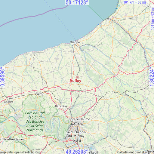
Auffay GPS coordinates[2]
49° 43' 7.716" North, 1° 5' 56.796" East
| Map corner | latitude | longitude |
|---|---|---|
| Upper-left | 50.17128°, | 0.39598° |
| Center: | 49.71881°, | 1.09911° |
| Lower-right: | 49.26208°, | 1.80224° |
| Map W x H: | 101.1×101.1 km | = 62.8×62.8mi |
| max Lat: | 51.07786° ⇑8.3% North |
| Auffay: | 49.71881° |
| min Lat: | ⇓91.7% South 41.3874° |
| min Long | Auffay | max Long |
| -5.08615° | 1.09911° | 9.52242° |
| W 32.1%⇐ | ⇒67.9% E |
Elevation
Elevation of Auffay is 94 m = 308 ft, and this is 99.7 m = 327 ft below average elevation for this country.
| Max E: |
2333 m = 7654 ft | 63.2% |
| Avg. | 193.7 m = 635 ft | |
| Auffay | 94 m = 308 ft | |
Min E: |
-1 m = -3 ft | 36.8% |
See also: France elevation on elevation.city.
Geographical zone
Auffay is located in North temperate zone (between Tropic of Cancer and the Arctic Circle). Distance of this North polar circle is 1873 km =1163.8 mi to North.| Distance of | km | miles | from Auffay |
|---|---|---|---|
| North Pole | 4478.8 | 2783 | to North |
| Arctic Circle | 1873 | 1163.8 | to North |
| Tropic Cancer | 2922.3 | 1815.8 | to South |
| Equator | 5528.2 | 3435.1 | to South |


Nearby cities:
15 places around Auffay: (largest is in red/bold)
• Bacqueville-en-Caux
10.5 km =6.5 mi,  316°
316°
• Bellencombre
9.2 km =5.7 mi,  97°
97°
• Biville-la-Baignarde
3.7 km =2.3 mi,  275°
275°
• Bosc-le-Hard
11.5 km =7.1 mi,  151°
151°
• Grugny
10.6 km =6.6 mi,  177°
177°
• Heugleville-sur-Scie
1.7 km =1.1 mi,  335°
335°
• La Houssaye-Béranger
9.6 km =6 mi,  186°
186°
• Les Grandes-Ventes
11.9 km =7.4 mi,  51°
51°
• Longueville-sur-Scie
8.1 km =5 mi,  5°
5°
• Orival
7.6 km =4.7 mi,  85°
85°
• Saint-Maclou-de-Folleville
4.2 km =2.6 mi,  172°
172°
• Saint-Ouen-du-Breuil
11 km =6.8 mi,  215°
215°
• Torcy-le-Grand
10.5 km =6.5 mi,  31°
31°
• Tôtes
5.7 km =3.5 mi, 221°
• Étaimpuis
8.7 km =5.4 mi,  159°
159°
Sources, notices
• [Note1] Compared only with cities in France existing in our database
• [Src1] Map data: © OpenStreetMap contributors (CC-BY-SA)
• [Src2] Other city data from geonames.org with taken over terms of usage.
• [Src3] Geographical zone / Annual Mean Temperature by Robert A. Rohde @ Wikipedia
