La Houssaye-Béranger geodata
La Houssaye-Béranger (Normandy) is a populated place; located in France in Europe/Paris (GMT+2) time zone. With population of 507 people, there are 15105 cities with bigger population in this country. Compared to other cities in France, 90.9% of cities are located further ↓South; 68% of cities are located further →East and 59.6% of cities have lower elevation than La Houssaye-Béranger. Note1
Administrative division(s):
- Level 1: Normandy
- Level 2: Seine-Maritime
- Level 3: Arrondissement de Rouen
- Level 4: La Houssaye-Béranger


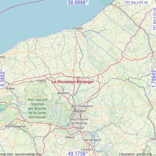
La Houssaye-Béranger GPS coordinates[2]
49° 37' 59.988" North, 1° 4' 59.988" East
| Map corner | latitude | longitude |
|---|---|---|
| Upper-left | 50.0866°, | 0.3802° |
| Center: | 49.63333°, | 1.08333° |
| Lower-right: | 49.1758°, | 1.78645° |
| Map W x H: | 101.3×101.3 km | = 62.9×62.9mi |
| max Lat: | 51.07786° ⇑9.1% North |
| La Houssaye-Béranger: | 49.63333° |
| min Lat: | ⇓90.9% South 41.3874° |
| min Long | La Houssaye-Bé | max Long |
| -5.08615° | 1.08333° | 9.52242° |
| W 32%⇐ | ⇒68% E |
Elevation
Elevation of La Houssaye-Béranger is 168 m = 551 ft, and this is 25.7 m = 84 ft below average elevation for this country.
| Max E: |
2333 m = 7654 ft | 40.4% |
| Avg. | 193.7 m = 635 ft | |
| La Houssaye-Béranger | 168 m = 551 ft | |
Min E: |
-1 m = -3 ft | 59.6% |
See also: France elevation on elevation.city.
Geographical zone
La Houssaye-Béranger is located in North temperate zone (between Tropic of Cancer and the Arctic Circle). Distance of this North polar circle is 1882.5 km =1169.7 mi to North.| Distance of | km | miles | from La Houssaye-Béranger |
|---|---|---|---|
| North Pole | 4488.4 | 2789 | to North |
| Arctic Circle | 1882.5 | 1169.7 | to North |
| Tropic Cancer | 2912.8 | 1809.9 | to South |
| Equator | 5518.7 | 3429.2 | to South |


Nearby cities:
15 places around La Houssaye-Béranger: (largest is in red/bold)
• Anceaumeville
7.3 km =4.5 mi,  198°
198°
• Auffay
9.6 km =6 mi,  6°
6°
• Bosc-le-Hard
6.6 km =4.1 mi,  95°
95°
• Clères
4.4 km =2.7 mi,  147°
147°
• Fontaine-le-Bourg
9.6 km =6 mi,  142°
142°
• Grugny
1.9 km =1.2 mi,  124°
124°
• Le Bocasse
3.7 km =2.3 mi,  180°
180°
• Mont-Cauvaire
7.2 km =4.5 mi,  164°
164°
• Saint-Maclou-de-Folleville
5.6 km =3.5 mi,  17°
17°
• Saint-Ouen-du-Breuil
5.3 km =3.3 mi,  276°
276°
• Sainte-Austreberthe
8.7 km =5.4 mi,  242°
242°
• Sierville
6 km =3.7 mi,  215°
215°
• Tôtes
5.9 km =3.7 mi,  333°
333°
• Émanville
9 km =5.6 mi,  262°
262°
• Étaimpuis
4.4 km =2.7 mi,  72°
72°
Sources, notices
• [Note1] Compared only with cities in France existing in our database
• [Src1] Map data: © OpenStreetMap contributors (CC-BY-SA)
• [Src2] Other city data from geonames.org with taken over terms of usage.
• [Src3] Geographical zone / Annual Mean Temperature by Robert A. Rohde @ Wikipedia
