Saint-Laurent geodata
Saint-Laurent (Nouvelle-Aquitaine) is a populated place; located in France in Europe/Paris (GMT+2) time zone. With population of 547 people, there are 14264 cities with bigger population in this country. Compared to other cities in France, 64.1% of cities are located further ↑North; 57.6% of cities are located further →East and 87.6% of cities have lower elevation than Saint-Laurent. Note1
Administrative division(s):
- Level 1: Nouvelle-Aquitaine
- Level 2: Creuse
- Level 3: Arrondissement de Guéret
- Level 4: Saint-Laurent


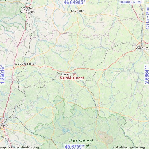
Saint-Laurent GPS coordinates[2]
46° 9' 54.108" North, 1° 57' 47.808" East
| Map corner | latitude | longitude |
|---|---|---|
| Upper-left | 46.64985°, | 1.26016° |
| Center: | 46.16503°, | 1.96328° |
| Lower-right: | 45.6759°, | 2.66641° |
| Map W x H: | 108.3×108.3 km | = 67.3×67.3mi |
| max Lat: | 51.07786° ⇑64.1% North |
| Saint-Laurent: | 46.16503° |
| min Lat: | ⇓35.9% South 41.3874° |
| min Long | Saint-Laurent | max Long |
| -5.08615° | 1.96328° | 9.52242° |
| W 42.4%⇐ | ⇒57.6% E |
Elevation
Elevation of Saint-Laurent is 383 m = 1257 ft, and this is 189.3 m = 621 ft above average elevation for this country.
| Max E: |
2333 m = 7654 ft | 12.4% |
| Saint-Laurent | 383 m 1257 ft | |
| Avg. | 193.7 m = 635 ft | |
Min E: |
-1 m = -3 ft | 87.6% |
See also: France elevation on elevation.city.
Geographical zone
Saint-Laurent is located in North temperate zone (between Tropic of Cancer and the Arctic Circle). Distance of this North polar circle is 2268.1 km =1409.3 mi to North.| Distance of | km | miles | from Saint-Laurent |
|---|---|---|---|
| North Pole | 4874 | 3028.6 | to North |
| Arctic Circle | 2268.1 | 1409.3 | to North |
| Tropic Cancer | 2527.2 | 1570.3 | to South |
| Equator | 5133.1 | 3189.6 | to South |


Nearby cities:
15 places around Saint-Laurent: (largest is in red/bold)
• Ahun
10.8 km =6.7 mi,  144°
144°
• Ajain
5.4 km =3.4 mi,  29°
29°
• Anzême
13.7 km =8.5 mi,  325°
325°
• Cressat
11.5 km =7.1 mi,  103°
103°
• Glénic
7.2 km =4.5 mi, 334°
• Guéret
7.1 km =4.4 mi,  276°
276°
• Jarnages
9.5 km =5.9 mi,  78°
78°
• La Saunière
4.3 km =2.7 mi,  208°
208°
• Lavaveix-les-Mines
14.2 km =8.8 mi, 137°
• Parsac
15.1 km =9.4 mi,  73°
73°
• Pionnat
4.8 km =3 mi, 82°
• Saint-Fiel
7.6 km =4.7 mi,  315°
315°
• Saint-Sulpice-le-Guérétois
11.1 km =6.9 mi,  290°
290°
• Sainte-Feyre
4.7 km =2.9 mi,  232°
232°
• Sardent
15.2 km =9.4 mi, 213°
Sources, notices
• [Note1] Compared only with cities in France existing in our database
• [Src1] Map data: © OpenStreetMap contributors (CC-BY-SA)
• [Src2] Other city data from geonames.org with taken over terms of usage.
• [Src3] Geographical zone / Annual Mean Temperature by Robert A. Rohde @ Wikipedia
