Saint-Fiel geodata
Saint-Fiel (Nouvelle-Aquitaine) is a populated place; located in France in Europe/Paris (GMT+2) time zone. With population of 780 people, there are 10827 cities with bigger population in this country. Compared to other cities in France, 63.3% of cities are located further ↑North; 58.4% of cities are located further →East and 85.2% of cities have lower elevation than Saint-Fiel. Note1
Administrative division(s):
- Level 1: Nouvelle-Aquitaine
- Level 2: Creuse
- Level 3: Arrondissement de Guéret
- Level 4: Saint-Fiel


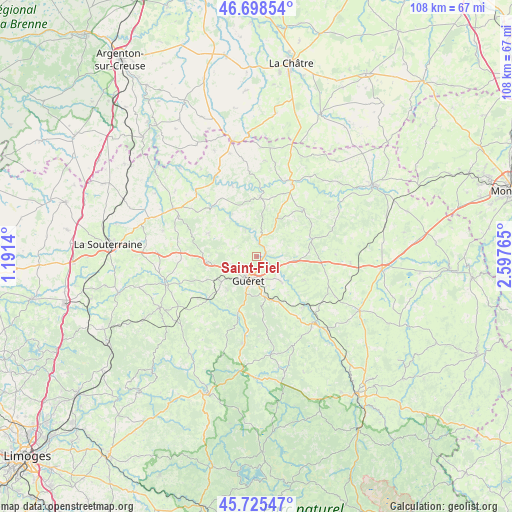
Saint-Fiel GPS coordinates[2]
46° 12' 50.976" North, 1° 53' 40.308" East
| Map corner | latitude | longitude |
|---|---|---|
| Upper-left | 46.69854°, | 1.1914° |
| Center: | 46.21416°, | 1.89453° |
| Lower-right: | 45.72547°, | 2.59765° |
| Map W x H: | 108.2×108.2 km | = 67.2×67.2mi |
| max Lat: | 51.07786° ⇑63.3% North |
| Saint-Fiel: | 46.21416° |
| min Lat: | ⇓36.7% South 41.3874° |
| min Long | Saint-Fiel | max Long |
| -5.08615° | 1.89453° | 9.52242° |
| W 41.6%⇐ | ⇒58.4% E |
Elevation
Elevation of Saint-Fiel is 349 m = 1145 ft, and this is 155.3 m = 510 ft above average elevation for this country.
| Max E: |
2333 m = 7654 ft | 14.8% |
| Saint-Fiel | 349 m 1145 ft | |
| Avg. | 193.7 m = 635 ft | |
Min E: |
-1 m = -3 ft | 85.2% |
See also: France elevation on elevation.city.
Geographical zone
Saint-Fiel is located in North temperate zone (between Tropic of Cancer and the Arctic Circle). Distance of this North polar circle is 2262.6 km =1405.9 mi to North.| Distance of | km | miles | from Saint-Fiel |
|---|---|---|---|
| North Pole | 4868.5 | 3025.1 | to North |
| Arctic Circle | 2262.6 | 1405.9 | to North |
| Tropic Cancer | 2532.6 | 1573.7 | to South |
| Equator | 5138.5 | 3192.9 | to South |


Nearby cities:
15 places around Saint-Fiel: (largest is in red/bold)
• Ajain
7.9 km =4.9 mi,  95°
95°
• Anzême
6.3 km =3.9 mi,  337°
337°
• Bonnat
12.7 km =7.9 mi,  3°
3°
• Bussière-Dunoise
11.3 km =7 mi,  295°
295°
• Châtelus-Malvaleix
14.2 km =8.8 mi,  44°
44°
• Glénic
2.4 km =1.5 mi,  64°
64°
• Guéret
5 km =3.1 mi,  200°
200°
• Jarnages
15 km =9.3 mi, 103°
• La Celle-Dunoise
14.1 km =8.8 mi,  317°
317°
• La Saunière
9.8 km =6.1 mi,  160°
160°
• Pionnat
11.2 km =7 mi,  115°
115°
• Saint-Laurent
7.6 km =4.7 mi,  135°
135°
• Saint-Sulpice-le-Guérétois
5.3 km =3.3 mi,  253°
253°
• Saint-Vaury
10.7 km =6.6 mi,  264°
264°
• Sainte-Feyre
8.5 km =5.3 mi,  169°
169°
Sources, notices
• [Note1] Compared only with cities in France existing in our database
• [Src1] Map data: © OpenStreetMap contributors (CC-BY-SA)
• [Src2] Other city data from geonames.org with taken over terms of usage.
• [Src3] Geographical zone / Annual Mean Temperature by Robert A. Rohde @ Wikipedia
