Anzême geodata
Anzême (Nouvelle-Aquitaine) is a populated place; located in France in Europe/Paris (GMT+2) time zone. With population of 540 people, there are 14387 cities with bigger population in this country. Compared to other cities in France, 62.7% of cities are located further ↑North; 58.7% of cities are located further →East and 85% of cities have lower elevation than Anzême. Note1
Administrative division(s):
- Level 1: Nouvelle-Aquitaine
- Level 2: Creuse
- Level 3: Arrondissement de Guéret
- Level 4: Anzême


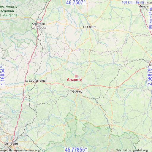
Anzême GPS coordinates[2]
46° 16' 0.408" North, 1° 51' 49.176" East
| Map corner | latitude | longitude |
|---|---|---|
| Upper-left | 46.7507°, | 1.16054° |
| Center: | 46.26678°, | 1.86366° |
| Lower-right: | 45.77855°, | 2.56679° |
| Map W x H: | 108.1×108.1 km | = 67.2×67.2mi |
| max Lat: | 51.07786° ⇑62.7% North |
| Anzême: | 46.26678° |
| min Lat: | ⇓37.3% South 41.3874° |
| min Long | Anzême | max Long |
| -5.08615° | 1.86366° | 9.52242° |
| W 41.3%⇐ | ⇒58.7% E |
Elevation
Elevation of Anzême is 346 m = 1135 ft, and this is 152.3 m = 500 ft above average elevation for this country.
| Max E: |
2333 m = 7654 ft | 15% |
| Anzême | 346 m 1135 ft | |
| Avg. | 193.7 m = 635 ft | |
Min E: |
-1 m = -3 ft | 85% |
See also: France elevation on elevation.city.
Geographical zone
Anzême is located in North temperate zone (between Tropic of Cancer and the Arctic Circle). Distance of this North polar circle is 2256.8 km =1402.3 mi to North.| Distance of | km | miles | from Anzême |
|---|---|---|---|
| North Pole | 4862.7 | 3021.5 | to North |
| Arctic Circle | 2256.8 | 1402.3 | to North |
| Tropic Cancer | 2538.5 | 1577.4 | to South |
| Equator | 5144.4 | 3196.6 | to South |


Nearby cities:
15 places around Anzême: (largest is in red/bold)
• Ajain
12.2 km =7.6 mi,  122°
122°
• Bonnat
7.5 km =4.7 mi,  24°
24°
• Bussière-Dunoise
7.8 km =4.8 mi,  263°
263°
• Châtelus-Malvaleix
13 km =8.1 mi,  71°
71°
• Chéniers
9.8 km =6.1 mi,  343°
343°
• Genouillac
13.7 km =8.5 mi,  46°
46°
• Glénic
6.6 km =4.1 mi,  136°
136°
• Guéret
10.6 km =6.6 mi,  176°
176°
• La Celle-Dunoise
8.5 km =5.3 mi,  303°
303°
• Saint-Fiel
6.3 km =3.9 mi,  157°
157°
• Saint-Laurent
13.7 km =8.5 mi,  145°
145°
• Saint-Sulpice-le-Dunois
11 km =6.8 mi,  289°
289°
• Saint-Sulpice-le-Guérétois
7.9 km =4.9 mi,  199°
199°
• Saint-Vaury
10.8 km =6.7 mi,  230°
230°
• Sainte-Feyre
14.7 km =9.1 mi, 164°
Sources, notices
• [Note1] Compared only with cities in France existing in our database
• [Src1] Map data: © OpenStreetMap contributors (CC-BY-SA)
• [Src2] Other city data from geonames.org with taken over terms of usage.
• [Src3] Geographical zone / Annual Mean Temperature by Robert A. Rohde @ Wikipedia
