Guéret geodata
Guéret (Nouvelle-Aquitaine) is a seat of a second-order administrative division; located in France in Europe/Paris (GMT+2) time zone. With population of 15,853 people, there are 606 cities with bigger population in this country. Compared to other cities in France, 64% of cities are located further ↑North; 58.6% of cities are located further →East and 91.2% of cities have lower elevation than Guéret. Note1
Administrative division(s):
- Level 1: Nouvelle-Aquitaine
- Level 2: Creuse
- Level 3: Arrondissement de Guéret
- Level 4: Guéret


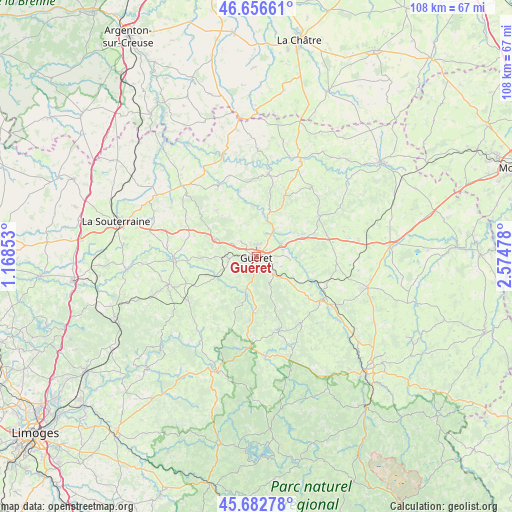
Guéret GPS coordinates[2]
46° 10' 18.66" North, 1° 52' 17.976" East
| Map corner | latitude | longitude |
|---|---|---|
| Upper-left | 46.65661°, | 1.16853° |
| Center: | 46.17185°, | 1.87166° |
| Lower-right: | 45.68278°, | 2.57478° |
| Map W x H: | 108.3×108.3 km | = 67.3×67.3mi |
| max Lat: | 51.07786° ⇑64% North |
| Guéret: | 46.17185° |
| min Lat: | ⇓36% South 41.3874° |
| min Long | Guéret | max Long |
| -5.08615° | 1.87166° | 9.52242° |
| W 41.4%⇐ | ⇒58.6% E |
Elevation
Elevation of Guéret is 454 m = 1490 ft, and this is 260.3 m = 854 ft above average elevation for this country.
| Max E: |
2333 m = 7654 ft | 8.8% |
| Guéret | 454 m 1490 ft | |
| Avg. | 193.7 m = 635 ft | |
Min E: |
-1 m = -3 ft | 91.2% |
See also: France elevation on elevation.city.
Geographical zone
Guéret is located in North temperate zone (between Tropic of Cancer and the Arctic Circle). Distance of this North polar circle is 2267.3 km =1408.8 mi to North.| Distance of | km | miles | from Guéret |
|---|---|---|---|
| North Pole | 4873.2 | 3028.1 | to North |
| Arctic Circle | 2267.3 | 1408.8 | to North |
| Tropic Cancer | 2527.9 | 1570.8 | to South |
| Equator | 5133.8 | 3190 | to South |


Nearby cities:
15 places around Guéret: (largest is in red/bold)
• Ahun
16.4 km =10.2 mi,  125°
125°
• Ajain
10.4 km =6.5 mi,  67°
67°
• Anzême
10.6 km =6.6 mi,  356°
356°
• Bussière-Dunoise
12.8 km =8 mi,  318°
318°
• Glénic
6.9 km =4.3 mi,  34°
34°
• Jarnages
16.4 km =10.2 mi,  85°
85°
• La Celle-Dunoise
17.1 km =10.6 mi,  333°
333°
• La Saunière
6.8 km =4.2 mi, 132°
• Pionnat
11.8 km =7.3 mi, 90°
• Saint-Fiel
5 km =3.1 mi,  20°
20°
• Saint-Laurent
7.1 km =4.4 mi,  96°
96°
• Saint-Sulpice-le-Guérétois
4.6 km =2.9 mi,  313°
313°
• Saint-Vaury
9.6 km =6 mi,  291°
291°
• Sainte-Feyre
5 km =3.1 mi,  137°
137°
• Sardent
13.5 km =8.4 mi,  185°
185°
Sources, notices
• [Note1] Compared only with cities in France existing in our database
• [Src1] Map data: © OpenStreetMap contributors (CC-BY-SA)
• [Src2] Other city data from geonames.org with taken over terms of usage.
• [Src3] Geographical zone / Annual Mean Temperature by Robert A. Rohde @ Wikipedia
