Margerie-Chantagret geodata
Margerie-Chantagret (Auvergne-Rhône-Alpes) is a populated place; located in France in Europe/Paris (GMT+2) time zone. With population of 523 people, there are 14759 cities with bigger population in this country. Compared to other cities in France, 73.8% of cities are located further ↑North; 68.5% of cities are located further ←West and 95.3% of cities have lower elevation than Margerie-Chantagret. Note1
Administrative division(s):
- Level 1: Auvergne-Rhône-Alpes
- Level 2: Département de la Loire
- Level 3: Arrondissement de Montbrison
- Level 4: Margerie-Chantagret


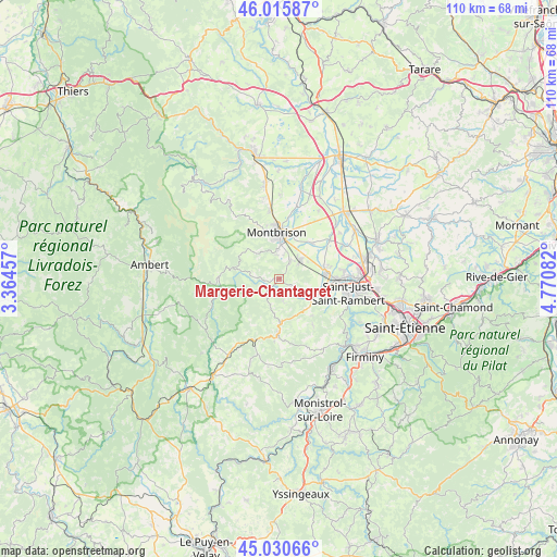
Margerie-Chantagret GPS coordinates[2]
45° 31' 31.512" North, 4° 4' 3.684" East
| Map corner | latitude | longitude |
|---|---|---|
| Upper-left | 46.01587°, | 3.36457° |
| Center: | 45.52542°, | 4.06769° |
| Lower-right: | 45.03066°, | 4.77082° |
| Map W x H: | 109.5×109.5 km | = 68×68mi |
| max Lat: | 51.07786° ⇑73.8% North |
| Margerie-Chantagret: | 45.52542° |
| min Lat: | ⇓26.2% South 41.3874° |
| min Long | Margerie-Chanta | max Long |
| -5.08615° | 4.06769° | 9.52242° |
| W 68.5%⇐ | ⇒31.5% E |
Elevation
Elevation of Margerie-Chantagret is 602 m = 1975 ft, and this is 408.3 m = 1340 ft above average elevation for this country.
| Max E: |
2333 m = 7654 ft | 4.7% |
| Margerie-Chantagret | 602 m 1975 ft | |
| Avg. | 193.7 m = 635 ft | |
Min E: |
-1 m = -3 ft | 95.3% |
See also: France elevation on elevation.city.
Geographical zone
Margerie-Chantagret is located in North temperate zone (between Tropic of Cancer and the Arctic Circle). Distance of this North polar circle is 2339.2 km =1453.5 mi to North.| Distance of | km | miles | from Margerie-Chantagret |
|---|---|---|---|
| North Pole | 4945.1 | 3072.7 | to North |
| Arctic Circle | 2339.2 | 1453.5 | to North |
| Tropic Cancer | 2456 | 1526.1 | to South |
| Equator | 5062 | 3145.4 | to South |


Nearby cities:
15 places around Margerie-Chantagret: (largest is in red/bold)
• Bard
8.3 km =5.2 mi,  327°
327°
• Boisset-Saint-Priest
3.1 km =1.9 mi,  115°
115°
• Bonson
11.3 km =7 mi,  91°
91°
• Luriecq
8.5 km =5.3 mi,  174°
174°
• Lézigneux
4.5 km =2.8 mi,  357°
357°
• Montbrison
9.1 km =5.7 mi, 358°
• Précieux
9.5 km =5.9 mi,  43°
43°
• Saint-Georges-Haute-Ville
4.2 km =2.6 mi,  33°
33°
• Saint-Jean-Soleymieux
3.5 km =2.2 mi,  220°
220°
• Saint-Marcellin-en-Forez
8.8 km =5.5 mi,  111°
111°
• Saint-Romain-le-Puy
5.7 km =3.5 mi,  49°
49°
• Saint-Thomas-la-Garde
4.7 km =2.9 mi,  11°
11°
• Savigneux
10.2 km =6.3 mi, 6°
• Sury-le-Comtal
9.3 km =5.8 mi,  81°
81°
• Verrières-en-Forez
7.6 km =4.7 mi,  312°
312°
Sources, notices
• [Note1] Compared only with cities in France existing in our database
• [Src1] Map data: © OpenStreetMap contributors (CC-BY-SA)
• [Src2] Other city data from geonames.org with taken over terms of usage.
• [Src3] Geographical zone / Annual Mean Temperature by Robert A. Rohde @ Wikipedia
