Périgneux geodata
Périgneux (Auvergne-Rhône-Alpes) is a populated place; located in France in Europe/Paris (GMT+2) time zone. With population of 1,250 people, there are 7281 cities with bigger population in this country. Compared to other cities in France, 74.8% of cities are located further ↑North; 69.3% of cities are located further ←West and 96.3% of cities have lower elevation than Périgneux. Note1
Administrative division(s):
- Level 1: Auvergne-Rhône-Alpes
- Level 2: Département de la Loire
- Level 3: Arrondissement de Montbrison
- Level 4: Périgneux


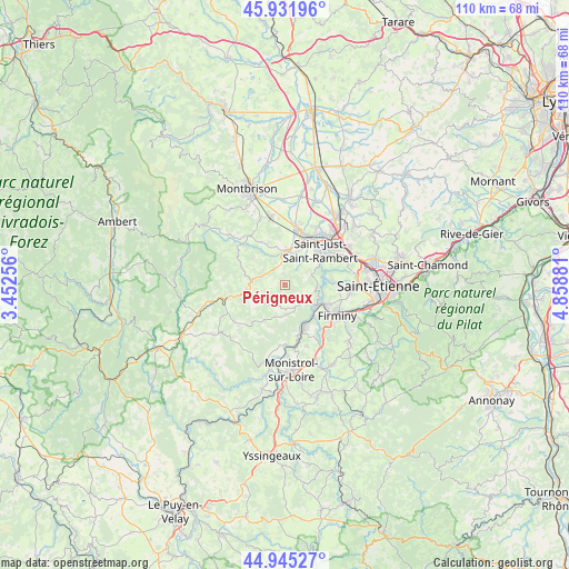
Périgneux GPS coordinates[2]
45° 26' 26.772" North, 4° 9' 20.484" East
| Map corner | latitude | longitude |
|---|---|---|
| Upper-left | 45.93196°, | 3.45256° |
| Center: | 45.44077°, | 4.15569° |
| Lower-right: | 44.94527°, | 4.85881° |
| Map W x H: | 109.7×109.7 km | = 68.2×68.2mi |
| max Lat: | 51.07786° ⇑74.8% North |
| Périgneux: | 45.44077° |
| min Lat: | ⇓25.2% South 41.3874° |
| min Long | Périgneux | max Long |
| -5.08615° | 4.15569° | 9.52242° |
| W 69.3%⇐ | ⇒30.7% E |
Elevation
Elevation of Périgneux is 665 m = 2182 ft, and this is 471.3 m = 1546 ft above average elevation for this country.
| Max E: |
2333 m = 7654 ft | 3.7% |
| Périgneux | 665 m 2182 ft | |
| Avg. | 193.7 m = 635 ft | |
Min E: |
-1 m = -3 ft | 96.3% |
See also: France elevation on elevation.city.
Geographical zone
Périgneux is located in North temperate zone (between Tropic of Cancer and the Arctic Circle). Distance of this North polar circle is 2348.6 km =1459.4 mi to North.| Distance of | km | miles | from Périgneux |
|---|---|---|---|
| North Pole | 4954.5 | 3078.6 | to North |
| Arctic Circle | 2348.6 | 1459.4 | to North |
| Tropic Cancer | 2446.6 | 1520.2 | to South |
| Equator | 5052.5 | 3139.5 | to South |


Nearby cities:
15 places around Périgneux: (largest is in red/bold)
• Aurec-sur-Loire
8.7 km =5.4 mi,  155°
155°
• Boisset-Saint-Priest
9 km =5.6 mi,  333°
333°
• Bonson
10.2 km =6.3 mi,  25°
25°
• Chambles
6.1 km =3.8 mi,  85°
85°
• Fraisses
10.2 km =6.3 mi,  124°
124°
• Luriecq
6.1 km =3.8 mi,  279°
279°
• Saint-Bonnet-le-Château
7.2 km =4.5 mi,  254°
254°
• Saint-Jean-Soleymieux
11.3 km =7 mi,  306°
306°
• Saint-Just-Saint-Rambert
9.4 km =5.8 mi,  45°
45°
• Saint-Marcellin-en-Forez
6.4 km =4 mi,  11°
11°
• Saint-Maurice-en-Gourgois
4.9 km =3 mi,  154°
154°
• Saint-Nizier-de-Fornas
7.1 km =4.4 mi,  234°
234°
• Saint-Paul
7.2 km =4.5 mi,  130°
130°
• Sury-le-Comtal
11 km =6.8 mi, 12°
• Unieux
9.9 km =6.2 mi,  114°
114°
Sources, notices
• [Note1] Compared only with cities in France existing in our database
• [Src1] Map data: © OpenStreetMap contributors (CC-BY-SA)
• [Src2] Other city data from geonames.org with taken over terms of usage.
• [Src3] Geographical zone / Annual Mean Temperature by Robert A. Rohde @ Wikipedia
