Châteauneuf geodata
Châteauneuf (Auvergne-Rhône-Alpes) is a populated place; located in France in Europe/Paris (GMT+2) time zone. With population of 621 people, there are 12967 cities with bigger population in this country. Compared to other cities in France, 73.4% of cities are located further ↑North; 89% of cities are located further ←West and 85.3% of cities have lower elevation than Châteauneuf. Note1
Administrative division(s):
- Level 1: Auvergne-Rhône-Alpes
- Level 2: Savoie
- Level 3: Arrondissement de Chambéry
- Level 4: Châteauneuf


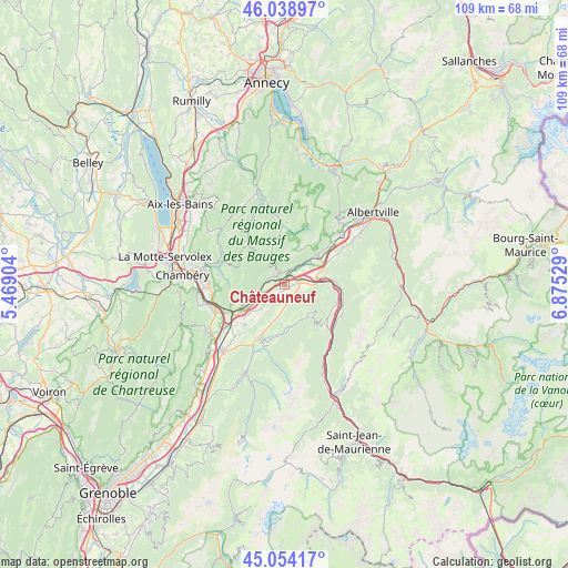
Châteauneuf GPS coordinates[2]
45° 32' 55.428" North, 6° 10' 19.812" East
| Map corner | latitude | longitude |
|---|---|---|
| Upper-left | 46.03897°, | 5.46904° |
| Center: | 45.54873°, | 6.17217° |
| Lower-right: | 45.05417°, | 6.87529° |
| Map W x H: | 109.5×109.5 km | = 68×68mi |
| max Lat: | 51.07786° ⇑73.4% North |
| Châteauneuf: | 45.54873° |
| min Lat: | ⇓26.6% South 41.3874° |
| min Long | Châteauneuf | max Long |
| -5.08615° | 6.17217° | 9.52242° |
| W 89%⇐ | ⇒11% E |
Elevation
Elevation of Châteauneuf is 350 m = 1148 ft, and this is 156.3 m = 513 ft above average elevation for this country.
| Max E: |
2333 m = 7654 ft | 14.7% |
| Châteauneuf | 350 m 1148 ft | |
| Avg. | 193.7 m = 635 ft | |
Min E: |
-1 m = -3 ft | 85.3% |
See also: France elevation on elevation.city.
Geographical zone
Châteauneuf is located in North temperate zone (between Tropic of Cancer and the Arctic Circle). Distance of this North polar circle is 2336.6 km =1451.9 mi to North.| Distance of | km | miles | from Châteauneuf |
|---|---|---|---|
| North Pole | 4942.5 | 3071.1 | to North |
| Arctic Circle | 2336.6 | 1451.9 | to North |
| Tropic Cancer | 2458.6 | 1527.7 | to South |
| Equator | 5064.5 | 3146.9 | to South |


Nearby cities:
15 places around Châteauneuf: (largest is in red/bold)
• Aiguebelle
10.3 km =6.4 mi,  92°
92°
• Aiton
6.9 km =4.3 mi,  78°
78°
• Arbin
8.9 km =5.5 mi,  242°
242°
• Argentine
12.5 km =7.8 mi,  119°
119°
• Chamoux-sur-Gelon
3.6 km =2.2 mi, 116°
• Coise
3.2 km =2 mi,  224°
224°
• Cruet
6.6 km =4.1 mi,  250°
250°
• Francin
12.1 km =7.5 mi, 243°
• Grésy-sur-Isère
8.4 km =5.2 mi,  48°
48°
• La Rochette
11.1 km =6.9 mi,  204°
204°
• Montailleur
11.2 km =7 mi, 47°
• Montmélian
10.2 km =6.3 mi, 241°
• Randens
10.7 km =6.6 mi, 91°
• Saint-Jean-de-la-Porte
3.4 km =2.1 mi,  284°
284°
• Sainte-Hélène-du-Lac
11.1 km =6.9 mi,  228°
228°
Sources, notices
• [Note1] Compared only with cities in France existing in our database
• [Src1] Map data: © OpenStreetMap contributors (CC-BY-SA)
• [Src2] Other city data from geonames.org with taken over terms of usage.
• [Src3] Geographical zone / Annual Mean Temperature by Robert A. Rohde @ Wikipedia
