Saint-Hilaire-Cottes geodata
Saint-Hilaire-Cottes (Hauts-de-France) is a populated place; located in France in Europe/Paris (GMT+2) time zone. With population of 752 people, there are 11147 cities with bigger population in this country. Compared to other cities in France, 97.9% of cities are located further ↓South; 50.9% of cities are located further →East and 87.1% of cities have higher elevation than Saint-Hilaire-Cottes. Note1
Administrative division(s):
- Level 1: Hauts-de-France
- Level 2: Pas-de-Calais
- Level 3: Arrondissement de Béthune
- Level 4: Saint-Hilaire-Cottes
Current local time in Saint-Hilaire-Cottes:
09:15 AM, WednesdayDifference from your time zone: hours


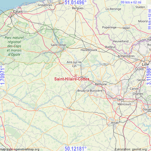
Saint-Hilaire-Cottes GPS coordinates[2]
50° 34' 13.8" North, 2° 24' 46.224" East
| Map corner | latitude | longitude |
|---|---|---|
| Upper-left | 51.01496°, | 1.70971° |
| Center: | 50.5705°, | 2.41284° |
| Lower-right: | 50.12181°, | 3.11596° |
| Map W x H: | 99.3×99.3 km | = 61.7×61.7mi |
| max Lat: | 51.07786° ⇑2.1% North |
| Saint-Hilaire-Cottes: | 50.5705° |
| min Lat: | ⇓97.9% South 41.3874° |
| min Long | Saint-Hilaire-C | max Long |
| -5.08615° | 2.41284° | 9.52242° |
| W 49.1%⇐ | ⇒50.9% E |
Elevation
Elevation of Saint-Hilaire-Cottes is 37 m = 121 ft, and this is 156.7 m = 514 ft below average elevation for this country.
| Max E: |
2333 m = 7654 ft | 87.1% |
| Avg. | 193.7 m = 635 ft | |
| Saint-Hilaire-Cottes | 37 m = 121 ft | |
Min E: |
-1 m = -3 ft | 12.9% |
See also: France elevation on elevation.city.
Geographical zone
Saint-Hilaire-Cottes is located in North temperate zone (between Tropic of Cancer and the Arctic Circle). Distance of this North polar circle is 1778.3 km =1105 mi to North.| Distance of | km | miles | from Saint-Hilaire-Cottes |
|---|---|---|---|
| North Pole | 4384.1 | 2724.2 | to North |
| Arctic Circle | 1778.3 | 1105 | to North |
| Tropic Cancer | 3017 | 1874.7 | to South |
| Equator | 5622.9 | 3493.9 | to South |


Nearby cities:
15 places around Saint-Hilaire-Cottes: (largest is in red/bold)
• Aire-sur-la-Lys
7.6 km =4.7 mi,  352°
352°
• Ames
3.3 km =2.1 mi,  177°
177°
• Bourecq
1.4 km =0.9 mi,  83°
83°
• Burbure
5.5 km =3.4 mi,  133°
133°
• Busnes
7.7 km =4.8 mi, 75°
• Estrée-Blanche
7 km =4.3 mi,  291°
291°
• Ferfay
5.8 km =3.6 mi,  171°
171°
• Guarbecque
7.1 km =4.4 mi,  49°
49°
• Ham-en-Artois
3.8 km =2.4 mi,  57°
57°
• Isbergues
6.7 km =4.2 mi,  29°
29°
• Lambres
5.4 km =3.4 mi, 347°
• Ligny-lès-Aire
4.7 km =2.9 mi,  251°
251°
• Lillers
4.8 km =3 mi,  99°
99°
• Norrent-Fontes
1.7 km =1.1 mi,  327°
327°
• Witternesse
5.7 km =3.5 mi,  319°
319°
Sources, notices
• [Note1] Compared only with cities in France existing in our database
• [Src1] Map data: © OpenStreetMap contributors (CC-BY-SA)
• [Src2] Other city data from geonames.org with taken over terms of usage.
• [Src3] Geographical zone / Annual Mean Temperature by Robert A. Rohde @ Wikipedia
