Burbure geodata
Burbure (Hauts-de-France) is a populated place; located in France in Europe/Paris (GMT+2) time zone. With population of 2,898 people, there are 3358 cities with bigger population in this country. Compared to other cities in France, 97.6% of cities are located further ↓South; 50.1% of cities are located further ←West and 83.1% of cities have higher elevation than Burbure. Note1
Administrative division(s):
- Level 1: Hauts-de-France
- Level 2: Pas-de-Calais
- Level 3: Arrondissement de Béthune
- Level 4: Burbure


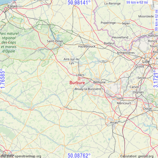
Burbure GPS coordinates[2]
50° 32' 11.868" North, 2° 28' 8.292" East
| Map corner | latitude | longitude |
|---|---|---|
| Upper-left | 50.98141°, | 1.76585° |
| Center: | 50.53663°, | 2.46897° |
| Lower-right: | 50.08762°, | 3.1721° |
| Map W x H: | 99.4×99.4 km | = 61.8×61.8mi |
| max Lat: | 51.07786° ⇑2.4% North |
| Burbure: | 50.53663° |
| min Lat: | ⇓97.6% South 41.3874° |
| min Long | Burbure | max Long |
| -5.08615° | 2.46897° | 9.52242° |
| W 50.1%⇐ | ⇒49.9% E |
Elevation
Elevation of Burbure is 47 m = 154 ft, and this is 146.7 m = 481 ft below average elevation for this country.
| Max E: |
2333 m = 7654 ft | 83.1% |
| Avg. | 193.7 m = 635 ft | |
| Burbure | 47 m = 154 ft | |
Min E: |
-1 m = -3 ft | 16.9% |
See also: France elevation on elevation.city.
Geographical zone
Burbure is located in North temperate zone (between Tropic of Cancer and the Arctic Circle). Distance of this North polar circle is 1782 km =1107.3 mi to North.| Distance of | km | miles | from Burbure |
|---|---|---|---|
| North Pole | 4387.9 | 2726.5 | to North |
| Arctic Circle | 1782 | 1107.3 | to North |
| Tropic Cancer | 3013.2 | 1872.3 | to South |
| Equator | 5619.1 | 3491.5 | to South |


Nearby cities:
15 places around Burbure: (largest is in red/bold)
• Allouagne
3.1 km =1.9 mi,  100°
100°
• Ames
3.8 km =2.4 mi,  276°
276°
• Auchel
3.7 km =2.3 mi,  175°
175°
• Bourecq
4.7 km =2.9 mi,  326°
326°
• Calonne-Ricouart
5.7 km =3.5 mi, 176°
• Camblain-Châtelain
6 km =3.7 mi,  189°
189°
• Cauchy-à-la-Tour
4 km =2.5 mi,  204°
204°
• Ferfay
3.7 km =2.3 mi,  237°
237°
• Floringhem
5.5 km =3.4 mi,  214°
214°
• Ham-en-Artois
5.9 km =3.7 mi,  352°
352°
• Lapugnoy
5.2 km =3.2 mi,  115°
115°
• Lillers
3.1 km =1.9 mi,  15°
15°
• Lozinghem
3.3 km =2.1 mi,  135°
135°
• Marles-les-Mines
4.5 km =2.8 mi, 141°
• Saint-Hilaire-Cottes
5.5 km =3.4 mi,  313°
313°
Sources, notices
• [Note1] Compared only with cities in France existing in our database
• [Src1] Map data: © OpenStreetMap contributors (CC-BY-SA)
• [Src2] Other city data from geonames.org with taken over terms of usage.
• [Src3] Geographical zone / Annual Mean Temperature by Robert A. Rohde @ Wikipedia
