Ferfay geodata
Ferfay (Hauts-de-France) is a populated place; located in France in Europe/Paris (GMT+2) time zone. With population of 899 people, there are 9669 cities with bigger population in this country. Compared to other cities in France, 97.5% of cities are located further ↓South; 50.6% of cities are located further →East and 59.1% of cities have higher elevation than Ferfay. Note1
Administrative division(s):
- Level 1: Hauts-de-France
- Level 2: Pas-de-Calais
- Level 3: Arrondissement de Béthune
- Level 4: Ferfay


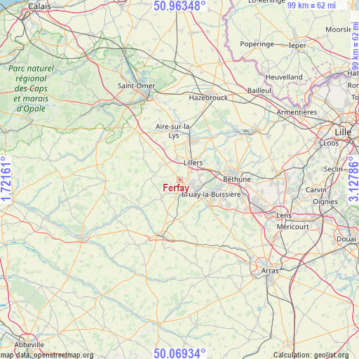
Ferfay GPS coordinates[2]
50° 31' 6.708" North, 2° 25' 29.064" East
| Map corner | latitude | longitude |
|---|---|---|
| Upper-left | 50.96348°, | 1.72161° |
| Center: | 50.51853°, | 2.42474° |
| Lower-right: | 50.06934°, | 3.12786° |
| Map W x H: | 99.4×99.4 km | = 61.8×61.8mi |
| max Lat: | 51.07786° ⇑2.5% North |
| Ferfay: | 50.51853° |
| min Lat: | ⇓97.5% South 41.3874° |
| min Long | Ferfay | max Long |
| -5.08615° | 2.42474° | 9.52242° |
| W 49.4%⇐ | ⇒50.6% E |
Elevation
Elevation of Ferfay is 105 m = 344 ft, and this is 88.7 m = 291 ft below average elevation for this country.
| Max E: |
2333 m = 7654 ft | 59.1% |
| Avg. | 193.7 m = 635 ft | |
| Ferfay | 105 m = 344 ft | |
Min E: |
-1 m = -3 ft | 40.9% |
See also: France elevation on elevation.city.
Geographical zone
Ferfay is located in North temperate zone (between Tropic of Cancer and the Arctic Circle). Distance of this North polar circle is 1784 km =1108.5 mi to North.| Distance of | km | miles | from Ferfay |
|---|---|---|---|
| North Pole | 4389.9 | 2727.8 | to North |
| Arctic Circle | 1784 | 1108.5 | to North |
| Tropic Cancer | 3011.2 | 1871.1 | to South |
| Equator | 5617.1 | 3490.3 | to South |


Nearby cities:
15 places around Ferfay: (largest is in red/bold)
• Allouagne
6.3 km =3.9 mi,  76°
76°
• Ames
2.6 km =1.6 mi,  344°
344°
• Auchel
3.8 km =2.4 mi,  115°
115°
• Bourecq
6 km =3.7 mi,  5°
5°
• Burbure
3.7 km =2.3 mi,  57°
57°
• Calonne-Ricouart
5.1 km =3.2 mi,  137°
137°
• Camblain-Châtelain
4.4 km =2.7 mi,  151°
151°
• Cauchy-à-la-Tour
2.2 km =1.4 mi, 137°
• Floringhem
2.5 km =1.6 mi,  178°
178°
• Ligny-lès-Aire
6.9 km =4.3 mi,  308°
308°
• Lillers
6.4 km =4 mi,  38°
38°
• Lozinghem
5.5 km =3.4 mi,  93°
93°
• Marles-les-Mines
6.1 km =3.8 mi,  104°
104°
• Pernes
3.9 km =2.4 mi,  192°
192°
• Saint-Hilaire-Cottes
5.8 km =3.6 mi,  351°
351°
Sources, notices
• [Note1] Compared only with cities in France existing in our database
• [Src1] Map data: © OpenStreetMap contributors (CC-BY-SA)
• [Src2] Other city data from geonames.org with taken over terms of usage.
• [Src3] Geographical zone / Annual Mean Temperature by Robert A. Rohde @ Wikipedia
