Le Vigan geodata
Le Vigan (Occitanie) is a populated place; located in France in Europe/Paris (GMT+2) time zone. With population of 1,276 people, there are 7143 cities with bigger population in this country. Compared to other cities in France, 81.8% of cities are located further ↑North; 63.8% of cities are located further →East and 73.2% of cities have lower elevation than Le Vigan. Note1
Administrative division(s):
- Level 1: Occitanie
- Level 2: Lot
- Level 3: Arrondissement de Gourdon
- Level 4: Le Vigan


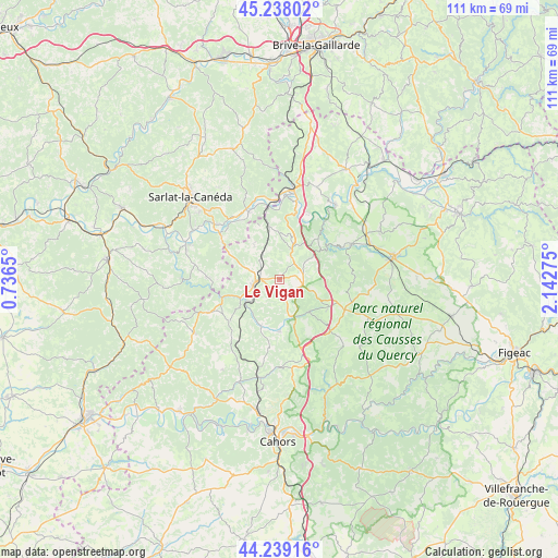
Le Vigan GPS coordinates[2]
44° 44' 26.7" North, 1° 26' 22.668" East
| Map corner | latitude | longitude |
|---|---|---|
| Upper-left | 45.23802°, | 0.7365° |
| Center: | 44.74075°, | 1.43963° |
| Lower-right: | 44.23916°, | 2.14275° |
| Map W x H: | 111.1×111.1 km | = 69×69mi |
| max Lat: | 51.07786° ⇑81.8% North |
| Le Vigan: | 44.74075° |
| min Lat: | ⇓18.2% South 41.3874° |
| min Long | Le Vigan | max Long |
| -5.08615° | 1.43963° | 9.52242° |
| W 36.2%⇐ | ⇒63.8% E |
Elevation
Elevation of Le Vigan is 237 m = 778 ft, and this is 43.3 m = 142 ft above average elevation for this country.
| Max E: |
2333 m = 7654 ft | 26.8% |
| Le Vigan | 237 m 778 ft | |
| Avg. | 193.7 m = 635 ft | |
Min E: |
-1 m = -3 ft | 73.2% |
See also: France elevation on elevation.city.
Geographical zone
Le Vigan is located in North temperate zone (between Tropic of Cancer and the Arctic Circle). Distance of this Northern Tropic circle is 2368.8 km =1471.9 mi to South.| Distance of | km | miles | from Le Vigan |
|---|---|---|---|
| North Pole | 5032.4 | 3127 | to North |
| Arctic Circle | 2426.5 | 1507.8 | to North |
| Tropic Cancer | 2368.8 | 1471.9 | to South |
| Equator | 4974.7 | 3091.1 | to South |


Nearby cities:
15 places around Le Vigan: (largest is in red/bold)
• Carlux
17.4 km =10.8 mi,  335°
335°
• Dégagnac
12.9 km =8 mi,  229°
229°
• Gourdon
4.5 km =2.8 mi,  265°
265°
• Groléjac
14.6 km =9.1 mi,  306°
306°
• Labastide-Murat
14.5 km =9 mi,  135°
135°
• Lanzac
15.2 km =9.4 mi,  13°
13°
• Montfaucon
11.3 km =7 mi,  121°
121°
• Payrac
6.7 km =4.2 mi,  22°
22°
• Payrignac
7.1 km =4.4 mi,  283°
283°
• Pinsac
14 km =8.7 mi, 24°
• Rocamadour
15.6 km =9.7 mi,  64°
64°
• Saint-Germain-du-Bel-Air
10.4 km =6.5 mi,  179°
179°
• Saint-Julien-de-Lampon
15.7 km =9.8 mi,  333°
333°
• Saint-Martial-de-Nabirat
14.3 km =8.9 mi, 271°
• Salviac
15.3 km =9.5 mi,  244°
244°
Sources, notices
• [Note1] Compared only with cities in France existing in our database
• [Src1] Map data: © OpenStreetMap contributors (CC-BY-SA)
• [Src2] Other city data from geonames.org with taken over terms of usage.
• [Src3] Geographical zone / Annual Mean Temperature by Robert A. Rohde @ Wikipedia
