Saint-Germain-des-Prés geodata
Saint-Germain-des-Prés (Centre) is a populated place; located in France in Europe/Paris (GMT+2) time zone. With population of 1,814 people, there are 5227 cities with bigger population in this country. Compared to other cities in France, 58.5% of cities are located further ↓South; 55.7% of cities are located further ←West and 55.2% of cities have higher elevation than Saint-Germain-des-Prés. Note1
Administrative division(s):
- Level 1: Centre
- Level 2: Loiret
- Level 3: Arrondissement de Montargis
- Level 4: Saint-Germain-des-Prés
Current local time in Saint-Germain-des-Prés:
04:42 AM, WednesdayDifference from your time zone: hours


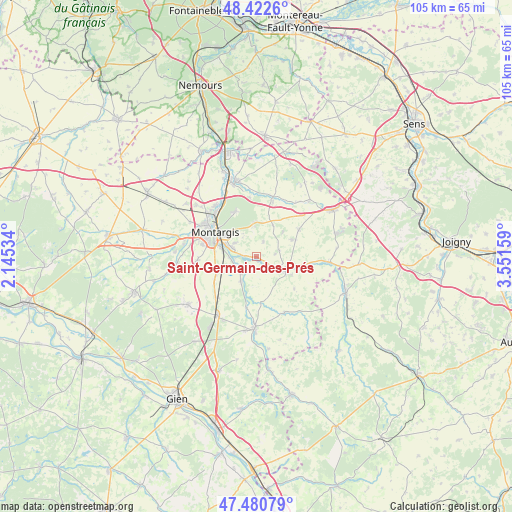
Saint-Germain-des-Prés GPS coordinates[2]
47° 57' 13.824" North, 2° 50' 54.456" East
| Map corner | latitude | longitude |
|---|---|---|
| Upper-left | 48.4226°, | 2.14534° |
| Center: | 47.95384°, | 2.84846° |
| Lower-right: | 47.48079°, | 3.55159° |
| Map W x H: | 104.7×104.7 km | = 65.1×65.1mi |
| max Lat: | 51.07786° ⇑41.5% North |
| Saint-Germain-des-Prés: | 47.95384° |
| min Lat: | ⇓58.5% South 41.3874° |
| min Long | Saint-Germain-d | max Long |
| -5.08615° | 2.84846° | 9.52242° |
| W 55.7%⇐ | ⇒44.3% E |
Elevation
Elevation of Saint-Germain-des-Prés is 116 m = 381 ft, and this is 77.7 m = 255 ft below average elevation for this country.
| Max E: |
2333 m = 7654 ft | 55.2% |
| Avg. | 193.7 m = 635 ft | |
| Saint-Germain-des-Prés | 116 m = 381 ft | |
Min E: |
-1 m = -3 ft | 44.8% |
See also: France elevation on elevation.city.
Geographical zone
Saint-Germain-des-Prés is located in North temperate zone (between Tropic of Cancer and the Arctic Circle). Distance of this North polar circle is 2069.2 km =1285.7 mi to North.| Distance of | km | miles | from Saint-Germain-des-Prés |
|---|---|---|---|
| North Pole | 4675.1 | 2905 | to North |
| Arctic Circle | 2069.2 | 1285.7 | to North |
| Tropic Cancer | 2726 | 1693.9 | to South |
| Equator | 5332 | 3313.2 | to South |


Nearby cities:
15 places around Saint-Germain-des-Prés: (largest is in red/bold)
• Amilly
6.1 km =3.8 mi,  290°
290°
• Chuelles
10.3 km =6.4 mi,  58°
58°
• Châlette-sur-Loing
10.7 km =6.6 mi,  308°
308°
• Château-Renard
6.7 km =4.2 mi,  109°
109°
• Gy-les-Nonains
0.8 km =0.5 mi,  168°
168°
• La Selle-en-Hermoy
7.3 km =4.5 mi,  28°
28°
• La Selle-sur-le-Bied
12.8 km =8 mi,  16°
16°
• Melleroy
10.2 km =6.3 mi,  129°
129°
• Montargis
9.9 km =6.2 mi,  299°
299°
• Montbouy
10.6 km =6.6 mi,  191°
191°
• Montcresson
6.2 km =3.9 mi,  209°
209°
• Paucourt
10.1 km =6.3 mi,  337°
337°
• Triguères
10.3 km =6.4 mi,  98°
98°
• Villemandeur
10.4 km =6.5 mi, 290°
• Vimory
12 km =7.5 mi,  266°
266°
Sources, notices
• [Note1] Compared only with cities in France existing in our database
• [Src1] Map data: © OpenStreetMap contributors (CC-BY-SA)
• [Src2] Other city data from geonames.org with taken over terms of usage.
• [Src3] Geographical zone / Annual Mean Temperature by Robert A. Rohde @ Wikipedia
