Château-Renard geodata
Château-Renard (Centre) is a populated place; located in France in Europe/Paris (GMT+2) time zone. With population of 2,296 people, there are 4203 cities with bigger population in this country. Compared to other cities in France, 58.1% of cities are located further ↓South; 56.8% of cities are located further ←West and 55.2% of cities have higher elevation than Château-Renard. Note1
Administrative division(s):
- Level 1: Centre
- Level 2: Loiret
- Level 3: Arrondissement de Montargis
- Level 4: Château-Renard


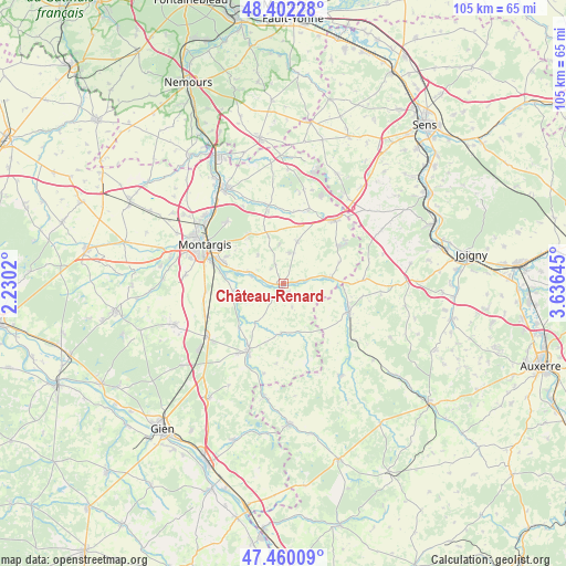
Château-Renard GPS coordinates[2]
47° 55' 59.988" North, 2° 55' 59.988" East
| Map corner | latitude | longitude |
|---|---|---|
| Upper-left | 48.40228°, | 2.2302° |
| Center: | 47.93333°, | 2.93333° |
| Lower-right: | 47.46009°, | 3.63645° |
| Map W x H: | 104.8×104.8 km | = 65.1×65.1mi |
| max Lat: | 51.07786° ⇑41.9% North |
| Château-Renard: | 47.93333° |
| min Lat: | ⇓58.1% South 41.3874° |
| min Long | Château-Renard | max Long |
| -5.08615° | 2.93333° | 9.52242° |
| W 56.8%⇐ | ⇒43.2% E |
Elevation
Elevation of Château-Renard is 116 m = 381 ft, and this is 77.7 m = 255 ft below average elevation for this country.
| Max E: |
2333 m = 7654 ft | 55.2% |
| Avg. | 193.7 m = 635 ft | |
| Château-Renard | 116 m = 381 ft | |
Min E: |
-1 m = -3 ft | 44.8% |
See also: France elevation on elevation.city.
Geographical zone
Château-Renard is located in North temperate zone (between Tropic of Cancer and the Arctic Circle). Distance of this North polar circle is 2071.5 km =1287.2 mi to North.| Distance of | km | miles | from Château-Renard |
|---|---|---|---|
| North Pole | 4677.4 | 2906.4 | to North |
| Arctic Circle | 2071.5 | 1287.2 | to North |
| Tropic Cancer | 2723.8 | 1692.5 | to South |
| Equator | 5329.7 | 3311.7 | to South |


Nearby cities:
15 places around Château-Renard: (largest is in red/bold)
• Amilly
12.8 km =8 mi,  290°
290°
• Charny
13.2 km =8.2 mi,  113°
113°
• Chuelles
8.1 km =5 mi,  17°
17°
• Châtillon-Coligny
13.9 km =8.6 mi,  207°
207°
• Douchy
9 km =5.6 mi,  83°
83°
• Gy-les-Nonains
6.4 km =4 mi,  283°
283°
• La Selle-en-Hermoy
9.1 km =5.7 mi,  342°
342°
• La Selle-sur-le-Bied
14.8 km =9.2 mi,  349°
349°
• Melleroy
4.5 km =2.8 mi,  160°
160°
• Montbouy
11.7 km =7.3 mi,  226°
226°
• Montcresson
9.8 km =6.1 mi,  251°
251°
• Saint-Germain-des-Prés
6.7 km =4.2 mi, 289°
• Saint-Hilaire-les-Andrésis
14.5 km =9 mi, 24°
• Saint-Maurice-sur-Aveyron
9.2 km =5.7 mi,  183°
183°
• Triguères
4 km =2.5 mi, 79°
Sources, notices
• [Note1] Compared only with cities in France existing in our database
• [Src1] Map data: © OpenStreetMap contributors (CC-BY-SA)
• [Src2] Other city data from geonames.org with taken over terms of usage.
• [Src3] Geographical zone / Annual Mean Temperature by Robert A. Rohde @ Wikipedia
