Saint-Geniès-de-Fontedit geodata
Saint-Geniès-de-Fontedit (Occitanie) is a populated place; located in France in Europe/Paris (GMT+2) time zone. With population of 1,351 people, there are 6807 cities with bigger population in this country. Compared to other cities in France, 93.5% of cities are located further ↑North; 60.3% of cities are located further ←West and 66% of cities have higher elevation than Saint-Geniès-de-Fontedit. Note1
Administrative division(s):
- Level 1: Occitanie
- Level 2: Département de l'Hérault
- Level 3: Arrondissement de Béziers
- Level 4: Saint-Geniès-de-Fontedit
Current local time in Saint-Geniès-de-Fontedit:
10:50 PM, SaturdayDifference from your time zone: hours


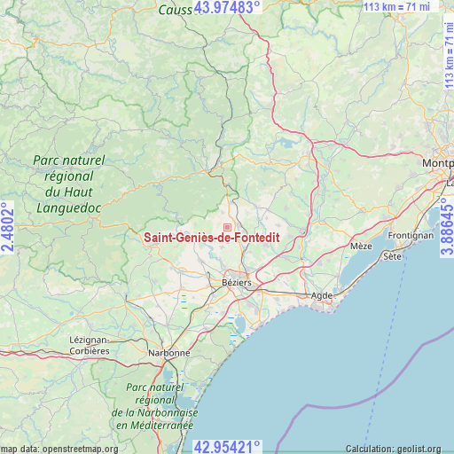
Saint-Geniès-de-Fontedit GPS coordinates[2]
43° 28' 0.012" North, 3° 10' 59.988" East
| Map corner | latitude | longitude |
|---|---|---|
| Upper-left | 43.97483°, | 2.4802° |
| Center: | 43.46667°, | 3.18333° |
| Lower-right: | 42.95421°, | 3.88645° |
| Map W x H: | 113.5×113.5 km | = 70.5×70.5mi |
| max Lat: | 51.07786° ⇑93.5% North |
| Saint-Geniès-de-Fontedit: | 43.46667° |
| min Lat: | ⇓6.5% South 41.3874° |
| min Long | Saint-Geniès-d | max Long |
| -5.08615° | 3.18333° | 9.52242° |
| W 60.3%⇐ | ⇒39.7% E |
Elevation
Elevation of Saint-Geniès-de-Fontedit is 87 m = 285 ft, and this is 106.7 m = 350 ft below average elevation for this country.
| Max E: |
2333 m = 7654 ft | 66% |
| Avg. | 193.7 m = 635 ft | |
| Saint-Geniès-de-Fontedit | 87 m = 285 ft | |
Min E: |
-1 m = -3 ft | 34% |
See also: France elevation on elevation.city.
Geographical zone
Saint-Geniès-de-Fontedit is located in North temperate zone (between Tropic of Cancer and the Arctic Circle). Distance of this Northern Tropic circle is 2227.1 km =1383.9 mi to South.| Distance of | km | miles | from Saint-Geniès-de-Fontedit |
|---|---|---|---|
| North Pole | 5174 | 3215 | to North |
| Arctic Circle | 2568.1 | 1595.7 | to North |
| Tropic Cancer | 2227.1 | 1383.9 | to South |
| Equator | 4833 | 3003.1 | to South |


Nearby cities:
15 places around Saint-Geniès-de-Fontedit: (largest is in red/bold)
• Autignac
3.8 km =2.4 mi,  342°
342°
• Bassan
8.4 km =5.2 mi,  137°
137°
• Causses-et-Veyran
7.9 km =4.9 mi,  276°
276°
• Corneilhan
7.5 km =4.7 mi,  174°
174°
• Espondeilhan
7.1 km =4.4 mi,  113°
113°
• Gabian
8.9 km =5.5 mi,  54°
54°
• Laurens
6.3 km =3.9 mi,  10°
10°
• Lieuran-lès-Béziers
6.9 km =4.3 mi, 140°
• Magalas
3.3 km =2.1 mi,  81°
81°
• Murviel-lès-Béziers
5.5 km =3.4 mi,  227°
227°
• Pailhès
4 km =2.5 mi,  178°
178°
• Pouzolles
8 km =5 mi, 76°
• Puimisson
3.7 km =2.3 mi,  150°
150°
• Puissalicon
4.4 km =2.7 mi,  102°
102°
• Thézan-lès-Béziers
5.7 km =3.5 mi,  193°
193°
Sources, notices
• [Note1] Compared only with cities in France existing in our database
• [Src1] Map data: © OpenStreetMap contributors (CC-BY-SA)
• [Src2] Other city data from geonames.org with taken over terms of usage.
• [Src3] Geographical zone / Annual Mean Temperature by Robert A. Rohde @ Wikipedia
