Gabian geodata
Gabian (Occitanie) is a populated place; located in France in Europe/Paris (GMT+2) time zone. With population of 749 people, there are 11176 cities with bigger population in this country. Compared to other cities in France, 92.9% of cities are located further ↑North; 61.7% of cities are located further ←West and 56.9% of cities have higher elevation than Gabian. Note1
Administrative division(s):
- Level 1: Occitanie
- Level 2: Département de l'Hérault
- Level 3: Arrondissement de Béziers
- Level 4: Gabian


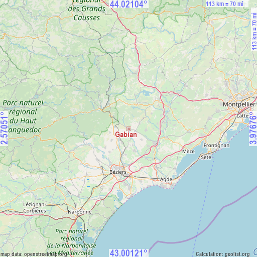
Gabian GPS coordinates[2]
43° 30' 47.808" North, 3° 16' 25.068" East
| Map corner | latitude | longitude |
|---|---|---|
| Upper-left | 44.02104°, | 2.57051° |
| Center: | 43.51328°, | 3.27363° |
| Lower-right: | 43.00121°, | 3.97676° |
| Map W x H: | 113.4×113.4 km | = 70.5×70.5mi |
| max Lat: | 51.07786° ⇑92.9% North |
| Gabian: | 43.51328° |
| min Lat: | ⇓7.1% South 41.3874° |
| min Long | Gabian | max Long |
| -5.08615° | 3.27363° | 9.52242° |
| W 61.7%⇐ | ⇒38.3% E |
Elevation
Elevation of Gabian is 111 m = 364 ft, and this is 82.7 m = 271 ft below average elevation for this country.
| Max E: |
2333 m = 7654 ft | 56.9% |
| Avg. | 193.7 m = 635 ft | |
| Gabian | 111 m = 364 ft | |
Min E: |
-1 m = -3 ft | 43.1% |
See also: France elevation on elevation.city.
Geographical zone
Gabian is located in North temperate zone (between Tropic of Cancer and the Arctic Circle). Distance of this Northern Tropic circle is 2232.3 km =1387.1 mi to South.| Distance of | km | miles | from Gabian |
|---|---|---|---|
| North Pole | 5168.8 | 3211.7 | to North |
| Arctic Circle | 2563 | 1592.6 | to North |
| Tropic Cancer | 2232.3 | 1387.1 | to South |
| Equator | 4838.2 | 3006.3 | to South |


Nearby cities:
15 places around Gabian: (largest is in red/bold)
• Abeilhan
7.3 km =4.5 mi,  166°
166°
• Alignan-du-Vent
7.3 km =4.5 mi,  131°
131°
• Autignac
8.6 km =5.3 mi,  259°
259°
• Caux
7.6 km =4.7 mi,  95°
95°
• Espondeilhan
8 km =5 mi,  185°
185°
• Fontès
9.1 km =5.7 mi,  71°
71°
• Laurens
6.2 km =3.9 mi,  279°
279°
• Magalas
6.2 km =3.9 mi,  220°
220°
• Neffiès
5.3 km =3.3 mi, 65°
• Pouzolles
3.4 km =2.1 mi, 171°
• Puimisson
10 km =6.2 mi,  213°
213°
• Puissalicon
6.8 km =4.2 mi, 205°
• Roujan
3.1 km =1.9 mi,  107°
107°
• Saint-Geniès-de-Fontedit
8.9 km =5.5 mi,  234°
234°
• Servian
9.8 km =6.1 mi, 167°
Sources, notices
• [Note1] Compared only with cities in France existing in our database
• [Src1] Map data: © OpenStreetMap contributors (CC-BY-SA)
• [Src2] Other city data from geonames.org with taken over terms of usage.
• [Src3] Geographical zone / Annual Mean Temperature by Robert A. Rohde @ Wikipedia
