Magalas geodata
Magalas (Occitanie) is a populated place; located in France in Europe/Paris (GMT+2) time zone. With population of 2,063 people, there are 4658 cities with bigger population in this country. Compared to other cities in France, 93.4% of cities are located further ↑North; 60.9% of cities are located further ←West and 51.4% of cities have higher elevation than Magalas. Note1
Administrative division(s):
- Level 1: Occitanie
- Level 2: Département de l'Hérault
- Level 3: Arrondissement de Béziers
- Level 4: Magalas


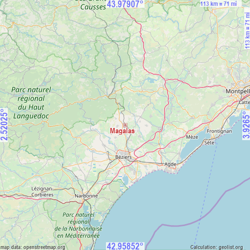
Magalas GPS coordinates[2]
43° 28' 15.42" North, 3° 13' 24.168" East
| Map corner | latitude | longitude |
|---|---|---|
| Upper-left | 43.97907°, | 2.52025° |
| Center: | 43.47095°, | 3.22338° |
| Lower-right: | 42.95852°, | 3.9265° |
| Map W x H: | 113.5×113.5 km | = 70.5×70.5mi |
| max Lat: | 51.07786° ⇑93.4% North |
| Magalas: | 43.47095° |
| min Lat: | ⇓6.6% South 41.3874° |
| min Long | Magalas | max Long |
| -5.08615° | 3.22338° | 9.52242° |
| W 60.9%⇐ | ⇒39.1% E |
Elevation
Elevation of Magalas is 127 m = 417 ft, and this is 66.7 m = 219 ft below average elevation for this country.
| Max E: |
2333 m = 7654 ft | 51.4% |
| Avg. | 193.7 m = 635 ft | |
| Magalas | 127 m = 417 ft | |
Min E: |
-1 m = -3 ft | 48.6% |
See also: France elevation on elevation.city.
Geographical zone
Magalas is located in North temperate zone (between Tropic of Cancer and the Arctic Circle). Distance of this Northern Tropic circle is 2227.6 km =1384.2 mi to South.| Distance of | km | miles | from Magalas |
|---|---|---|---|
| North Pole | 5173.5 | 3214.7 | to North |
| Arctic Circle | 2567.7 | 1595.5 | to North |
| Tropic Cancer | 2227.6 | 1384.2 | to South |
| Equator | 4833.5 | 3003.4 | to South |


Nearby cities:
15 places around Magalas: (largest is in red/bold)
• Abeilhan
6.3 km =3.9 mi,  112°
112°
• Autignac
5.4 km =3.4 mi,  305°
305°
• Bassan
7.2 km =4.5 mi,  159°
159°
• Espondeilhan
4.6 km =2.9 mi,  135°
135°
• Gabian
6.2 km =3.9 mi,  40°
40°
• Laurens
6.1 km =3.8 mi,  339°
339°
• Lieuran-lès-Béziers
5.9 km =3.7 mi,  169°
169°
• Pailhès
5.4 km =3.4 mi,  214°
214°
• Pouzolles
4.7 km =2.9 mi,  73°
73°
• Puimisson
4 km =2.5 mi,  201°
201°
• Puissalicon
1.8 km =1.1 mi, 142°
• Roujan
8 km =5 mi,  61°
61°
• Saint-Geniès-de-Fontedit
3.3 km =2.1 mi,  261°
261°
• Servian
7.9 km =4.9 mi,  128°
128°
• Thézan-lès-Béziers
7.6 km =4.7 mi,  217°
217°
Sources, notices
• [Note1] Compared only with cities in France existing in our database
• [Src1] Map data: © OpenStreetMap contributors (CC-BY-SA)
• [Src2] Other city data from geonames.org with taken over terms of usage.
• [Src3] Geographical zone / Annual Mean Temperature by Robert A. Rohde @ Wikipedia
