Saint-Sébastien-sur-Loire geodata
Saint-Sébastien-sur-Loire (Pays de la Loire) is a populated place; located in France in Europe/Paris (GMT+2) time zone. With population of 29,238 people, there are 284 cities with bigger population in this country. Compared to other cities in France, 52.9% of cities are located further ↑North; 92.3% of cities are located further →East and 95% of cities have higher elevation than Saint-Sébastien-sur-Loire. Note1
Administrative division(s):
- Level 1: Pays de la Loire
- Level 2: Loire-Atlantique
- Level 3: Arrondissement de Nantes
- Level 4: Saint-Sébastien-sur-Loire
Current local time in Saint-Sébastien-sur-Loire:
06:40 PM, SaturdayDifference from your time zone: hours


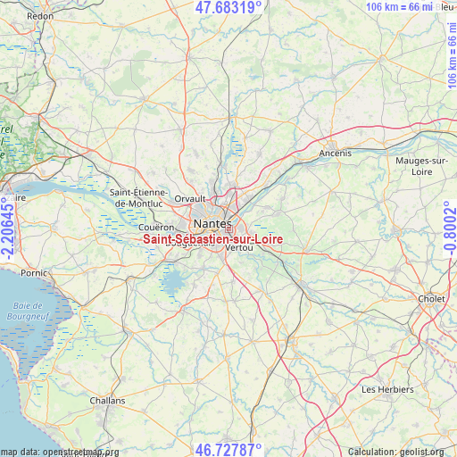
Saint-Sébastien-sur-Loire GPS coordinates[2]
47° 12' 27.648" North, 1° 30' 11.952" West
| Map corner | latitude | longitude |
|---|---|---|
| Upper-left | 47.68319°, | -2.20645° |
| Center: | 47.20768°, | -1.50332° |
| Lower-right: | 46.72787°, | -0.8002° |
| Map W x H: | 106.2×106.2 km | = 66×66mi |
| max Lat: | 51.07786° ⇑52.9% North |
| Saint-Sébastien-sur-Loire: | 47.20768° |
| min Lat: | ⇓47.1% South 41.3874° |
| min Long | Saint-Sébastie | max Long |
| -5.08615° | -1.50332° | 9.52242° |
| W 7.7%⇐ | ⇒92.3% E |
Elevation
Elevation of Saint-Sébastien-sur-Loire is 17 m = 56 ft, and this is 176.7 m = 580 ft below average elevation for this country.
| Max E: |
2333 m = 7654 ft | 95% |
| Avg. | 193.7 m = 635 ft | |
| Saint-Sébastien-sur-Loire | 17 m = 56 ft | |
Min E: |
-1 m = -3 ft | 5% |
See also: France elevation on elevation.city.
Geographical zone
Saint-Sébastien-sur-Loire is located in North temperate zone (between Tropic of Cancer and the Arctic Circle). Distance of this North polar circle is 2152.2 km =1337.3 mi to North.| Distance of | km | miles | from Saint-Sébastien-sur-Loire |
|---|---|---|---|
| North Pole | 4758.1 | 2956.5 | to North |
| Arctic Circle | 2152.2 | 1337.3 | to North |
| Tropic Cancer | 2643.1 | 1642.3 | to South |
| Equator | 5249 | 3261.6 | to South |


Nearby cities:
15 places around Saint-Sébastien-sur-Loire: (largest is in red/bold)
• Basse-Goulaine
2.7 km =1.7 mi,  80°
80°
• Bouguenais
9.5 km =5.9 mi,  249°
249°
• Carquefou
10.1 km =6.3 mi,  5°
5°
• Haute-Goulaine
5.7 km =3.5 mi,  99°
99°
• La Chapelle-sur-Erdre
10.5 km =6.5 mi,  339°
339°
• La Haie-Fouassière
9.9 km =6.2 mi,  126°
126°
• Les Sorinières
6.9 km =4.3 mi,  196°
196°
• Nantes
3.9 km =2.4 mi,  285°
285°
• Rezé
4.6 km =2.9 mi,  230°
230°
• Saint-Fiacre-sur-Maine
9.7 km =6 mi,  138°
138°
• Saint-Herblain
11 km =6.8 mi,  275°
275°
• Saint-Julien-de-Concelles
10.3 km =6.4 mi,  60°
60°
• Sainte-Luce-sur-Loire
5.3 km =3.3 mi,  15°
15°
• Thouaré-sur-Loire
8.4 km =5.2 mi,  35°
35°
• Vertou
5 km =3.1 mi,  149°
149°
In other languages:
- In Spanish: San Sebastián sobre Loira
- In Russian: Санкт-Себастьян-сюр-Луар
- In Chinese: 卢瓦尔河畔圣塞巴斯蒂安
Sources, notices
• [Note1] Compared only with cities in France existing in our database
• [Src1] Map data: © OpenStreetMap contributors (CC-BY-SA)
• [Src2] Other city data from geonames.org with taken over terms of usage.
• [Src3] Geographical zone / Annual Mean Temperature by Robert A. Rohde @ Wikipedia
