Andé geodata
Andé (Normandy) is a populated place; located in France in Europe/Paris (GMT+2) time zone. With population of 1,043 people, there are 8513 cities with bigger population in this country. Compared to other cities in France, 84.8% of cities are located further ↓South; 66.2% of cities are located further →East and 93.6% of cities have higher elevation than Andé. Note1
Administrative division(s):
- Level 1: Normandy
- Level 2: Département de l'Eure
- Level 3: Les Andelys
- Level 4: Andé


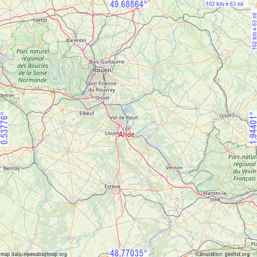
Andé GPS coordinates[2]
49° 13' 53.868" North, 1° 14' 27.168" East
| Map corner | latitude | longitude |
|---|---|---|
| Upper-left | 49.68864°, | 0.53776° |
| Center: | 49.23163°, | 1.24088° |
| Lower-right: | 48.77035°, | 1.94401° |
| Map W x H: | 102.1×102.1 km | = 63.4×63.4mi |
| max Lat: | 51.07786° ⇑15.2% North |
| Andé: | 49.23163° |
| min Lat: | ⇓84.8% South 41.3874° |
| min Long | Andé | max Long |
| -5.08615° | 1.24088° | 9.52242° |
| W 33.8%⇐ | ⇒66.2% E |
Elevation
Elevation of Andé is 21 m = 69 ft, and this is 172.7 m = 567 ft below average elevation for this country.
| Max E: |
2333 m = 7654 ft | 93.6% |
| Avg. | 193.7 m = 635 ft | |
| Andé | 21 m = 69 ft | |
Min E: |
-1 m = -3 ft | 6.4% |
See also: France elevation on elevation.city.
Geographical zone
Andé is located in North temperate zone (between Tropic of Cancer and the Arctic Circle). Distance of this North polar circle is 1927.1 km =1197.4 mi to North.| Distance of | km | miles | from Andé |
|---|---|---|---|
| North Pole | 4533 | 2816.7 | to North |
| Arctic Circle | 1927.1 | 1197.4 | to North |
| Tropic Cancer | 2868.1 | 1782.2 | to South |
| Equator | 5474 | 3401.4 | to South |


Nearby cities:
15 places around Andé: (largest is in red/bold)
• Acquigny
8 km =5 mi,  215°
215°
• Fontaine-Bellenger
5.3 km =3.3 mi,  163°
163°
• Heudebouville
4.1 km =2.5 mi,  180°
180°
• Le Vaudreuil
3.4 km =2.1 mi,  317°
317°
• Les Damps
9.1 km =5.7 mi,  329°
329°
• Louviers
5.6 km =3.5 mi,  252°
252°
• Léry
6.5 km =4 mi,  338°
338°
• Muids
3.7 km =2.3 mi,  104°
104°
• Pinterville
6.5 km =4 mi,  226°
226°
• Poses
8.2 km =5.1 mi,  1°
1°
• Saint-Pierre-du-Vauvray
1.4 km =0.9 mi,  272°
272°
• Saint-Étienne-du-Vauvray
1.9 km =1.2 mi,  305°
305°
• Val-de-Reuil
5.2 km =3.2 mi, 334°
• Venables
5.3 km =3.3 mi,  132°
132°
• Villers-sur-le-Roule
7.3 km =4.5 mi,  122°
122°
Sources, notices
• [Note1] Compared only with cities in France existing in our database
• [Src1] Map data: © OpenStreetMap contributors (CC-BY-SA)
• [Src2] Other city data from geonames.org with taken over terms of usage.
• [Src3] Geographical zone / Annual Mean Temperature by Robert A. Rohde @ Wikipedia
