Val-de-Reuil geodata
Val-de-Reuil (Normandy) is a populated place; located in France in Europe/Paris (GMT+2) time zone. With population of 13,824 people, there are 686 cities with bigger population in this country. Compared to other cities in France, 85.5% of cities are located further ↓South; 66.6% of cities are located further →East and 96.3% of cities have higher elevation than Val-de-Reuil. Note1
Administrative division(s):
- Level 1: Normandy
- Level 2: Département de l'Eure
- Level 3: Les Andelys
- Level 4: Val-de-Reuil


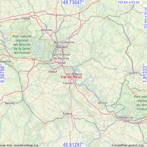
Val-de-Reuil GPS coordinates[2]
49° 16' 25.86" North, 1° 12' 36.756" East
| Map corner | latitude | longitude |
|---|---|---|
| Upper-left | 49.73047°, | 0.50708° |
| Center: | 49.27385°, | 1.21021° |
| Lower-right: | 48.81297°, | 1.91333° |
| Map W x H: | 102×102 km | = 63.4×63.4mi |
| max Lat: | 51.07786° ⇑14.5% North |
| Val-de-Reuil: | 49.27385° |
| min Lat: | ⇓85.5% South 41.3874° |
| min Long | Val-de-Reuil | max Long |
| -5.08615° | 1.21021° | 9.52242° |
| W 33.4%⇐ | ⇒66.6% E |
Elevation
Elevation of Val-de-Reuil is 13 m = 43 ft, and this is 180.7 m = 593 ft below average elevation for this country.
| Max E: |
2333 m = 7654 ft | 96.3% |
| Avg. | 193.7 m = 635 ft | |
| Val-de-Reuil | 13 m = 43 ft | |
Min E: |
-1 m = -3 ft | 3.7% |
See also: France elevation on elevation.city.
Geographical zone
Val-de-Reuil is located in North temperate zone (between Tropic of Cancer and the Arctic Circle). Distance of this North polar circle is 1922.4 km =1194.5 mi to North.| Distance of | km | miles | from Val-de-Reuil |
|---|---|---|---|
| North Pole | 4528.3 | 2813.8 | to North |
| Arctic Circle | 1922.4 | 1194.5 | to North |
| Tropic Cancer | 2872.8 | 1785.1 | to South |
| Equator | 5478.7 | 3404.3 | to South |


Nearby cities:
15 places around Val-de-Reuil: (largest is in red/bold)
• Alizay
5.8 km =3.6 mi,  336°
336°
• Andé
5.2 km =3.2 mi,  154°
154°
• Igoville
6.8 km =4.2 mi,  318°
318°
• Le Manoir
4.4 km =2.7 mi,  354°
354°
• Le Vaudreuil
2.2 km =1.4 mi,  181°
181°
• Les Damps
3.9 km =2.4 mi, 323°
• Louviers
7.1 km =4.4 mi,  206°
206°
• Léry
1.3 km =0.8 mi, 352°
• Muids
8.1 km =5 mi,  134°
134°
• Poses
4.3 km =2.7 mi,  34°
34°
• Pîtres
5 km =3.1 mi,  19°
19°
• Romilly-sur-Andelle
7.4 km =4.6 mi, 29°
• Saint-Pierre-du-Vauvray
4.7 km =2.9 mi,  170°
170°
• Saint-Étienne-du-Vauvray
3.6 km =2.2 mi, 169°
• Sotteville-sous-le-Val
8 km =5 mi,  308°
308°
Sources, notices
• [Note1] Compared only with cities in France existing in our database
• [Src1] Map data: © OpenStreetMap contributors (CC-BY-SA)
• [Src2] Other city data from geonames.org with taken over terms of usage.
• [Src3] Geographical zone / Annual Mean Temperature by Robert A. Rohde @ Wikipedia
