Léry geodata
Léry (Normandy) is a populated place; located in France in Europe/Paris (GMT+2) time zone. With population of 2,244 people, there are 4288 cities with bigger population in this country. Compared to other cities in France, 85.8% of cities are located further ↓South; 66.7% of cities are located further →East and 97% of cities have higher elevation than Léry. Note1
Administrative division(s):
- Level 1: Normandy
- Level 2: Département de l'Eure
- Level 3: Les Andelys
- Level 4: Léry


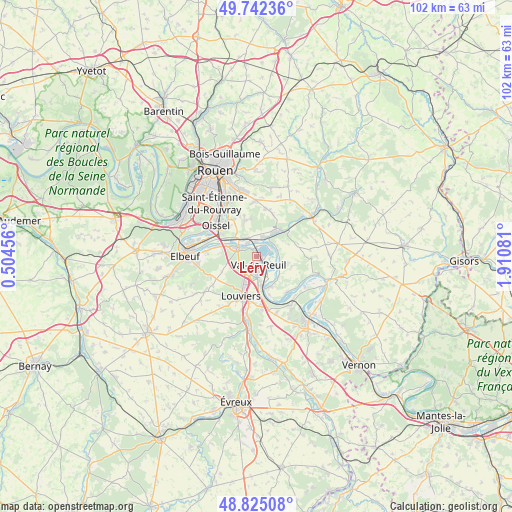
Léry GPS coordinates[2]
49° 17' 9.06" North, 1° 12' 27.648" East
| Map corner | latitude | longitude |
|---|---|---|
| Upper-left | 49.74236°, | 0.50456° |
| Center: | 49.28585°, | 1.20768° |
| Lower-right: | 48.82508°, | 1.91081° |
| Map W x H: | 102×102 km | = 63.4×63.4mi |
| max Lat: | 51.07786° ⇑14.2% North |
| Léry: | 49.28585° |
| min Lat: | ⇓85.8% South 41.3874° |
| min Long | Léry | max Long |
| -5.08615° | 1.20768° | 9.52242° |
| W 33.3%⇐ | ⇒66.7% E |
Elevation
Elevation of Léry is 11 m = 36 ft, and this is 182.7 m = 599 ft below average elevation for this country.
| Max E: |
2333 m = 7654 ft | 97% |
| Avg. | 193.7 m = 635 ft | |
| Léry | 11 m = 36 ft | |
Min E: |
-1 m = -3 ft | 3% |
See also: France elevation on elevation.city.
Geographical zone
Léry is located in North temperate zone (between Tropic of Cancer and the Arctic Circle). Distance of this North polar circle is 1921.1 km =1193.7 mi to North.| Distance of | km | miles | from Léry |
|---|---|---|---|
| North Pole | 4527 | 2812.9 | to North |
| Arctic Circle | 1921.1 | 1193.7 | to North |
| Tropic Cancer | 2874.2 | 1785.9 | to South |
| Equator | 5480.1 | 3405.2 | to South |


Nearby cities:
15 places around Léry: (largest is in red/bold)
• Alizay
4.5 km =2.8 mi,  331°
331°
• Andé
6.5 km =4 mi,  158°
158°
• Igoville
5.7 km =3.5 mi,  311°
311°
• Le Manoir
3.1 km =1.9 mi,  355°
355°
• Le Vaudreuil
3.5 km =2.2 mi,  177°
177°
• Les Damps
2.8 km =1.7 mi, 309°
• Pont-Saint-Pierre
7.4 km =4.6 mi,  41°
41°
• Poses
3.4 km =2.1 mi,  50°
50°
• Pîtres
3.9 km =2.4 mi,  28°
28°
• Romilly-sur-Andelle
6.4 km =4 mi, 37°
• Saint-Pierre-du-Vauvray
6.1 km =3.8 mi,  170°
170°
• Saint-Étienne-du-Vauvray
5 km =3.1 mi, 170°
• Sotteville-sous-le-Val
7.1 km =4.4 mi,  301°
301°
• Val-de-Reuil
1.3 km =0.8 mi, 172°
• Ymare
7.5 km =4.7 mi,  344°
344°
Sources, notices
• [Note1] Compared only with cities in France existing in our database
• [Src1] Map data: © OpenStreetMap contributors (CC-BY-SA)
• [Src2] Other city data from geonames.org with taken over terms of usage.
• [Src3] Geographical zone / Annual Mean Temperature by Robert A. Rohde @ Wikipedia
