Eyragues geodata
Eyragues (Provence-Alpes-Côte d'Azur) is a populated place; located in France in Europe/Paris (GMT+2) time zone. With population of 4,146 people, there are 2369 cities with bigger population in this country. Compared to other cities in France, 88.7% of cities are located further ↑North; 75.7% of cities are located further ←West and 90.7% of cities have higher elevation than Eyragues. Note1
Administrative division(s):
- Level 1: Provence-Alpes-Côte d'Azur
- Level 2: Département des Bouches-du-Rhône
- Level 3: Arles
- Level 4: Eyragues


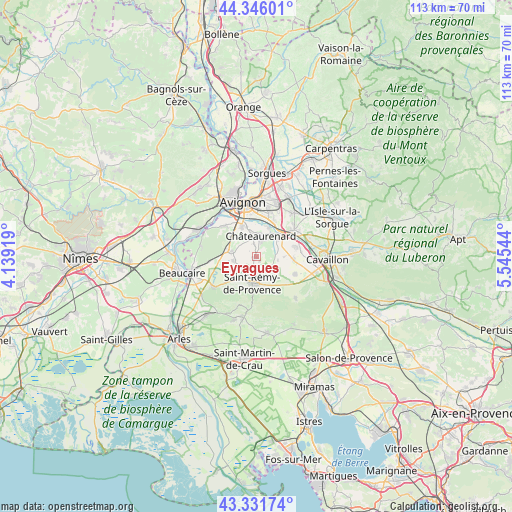
Eyragues GPS coordinates[2]
43° 50' 27.708" North, 4° 50' 32.316" East
| Map corner | latitude | longitude |
|---|---|---|
| Upper-left | 44.34601°, | 4.13919° |
| Center: | 43.84103°, | 4.84231° |
| Lower-right: | 43.33174°, | 5.54544° |
| Map W x H: | 112.8×112.8 km | = 70.1×70.1mi |
| max Lat: | 51.07786° ⇑88.7% North |
| Eyragues: | 43.84103° |
| min Lat: | ⇓11.3% South 41.3874° |
| min Long | Eyragues | max Long |
| -5.08615° | 4.84231° | 9.52242° |
| W 75.7%⇐ | ⇒24.3% E |
Elevation
Elevation of Eyragues is 28 m = 92 ft, and this is 165.7 m = 544 ft below average elevation for this country.
| Max E: |
2333 m = 7654 ft | 90.7% |
| Avg. | 193.7 m = 635 ft | |
| Eyragues | 28 m = 92 ft | |
Min E: |
-1 m = -3 ft | 9.3% |
See also: France elevation on elevation.city.
Geographical zone
Eyragues is located in North temperate zone (between Tropic of Cancer and the Arctic Circle). Distance of this Northern Tropic circle is 2268.7 km =1409.7 mi to South.| Distance of | km | miles | from Eyragues |
|---|---|---|---|
| North Pole | 5132.4 | 3189.1 | to North |
| Arctic Circle | 2526.5 | 1569.9 | to North |
| Tropic Cancer | 2268.7 | 1409.7 | to South |
| Equator | 4874.7 | 3029 | to South |


Nearby cities:
15 places around Eyragues: (largest is in red/bold)
• Barbentane
10 km =6.2 mi,  310°
310°
• Cabannes
9 km =5.6 mi,  76°
76°
• Caumont-sur-Durance
10.3 km =6.4 mi,  55°
55°
• Châteaurenard
4.6 km =2.9 mi,  12°
12°
• Graveson
5.6 km =3.5 mi,  280°
280°
• Maillane
4.9 km =3 mi,  259°
259°
• Mollégès
9.4 km =5.8 mi,  113°
113°
• Montfavet
10.6 km =6.6 mi, 13°
• Morières-lès-Avignon
12 km =7.5 mi,  23°
23°
• Noves
6.3 km =3.9 mi,  50°
50°
• Rognonas
7.2 km =4.5 mi,  334°
334°
• Saint-Andiol
8.2 km =5.1 mi,  94°
94°
• Saint-Rémy-de-Provence
5.9 km =3.7 mi,  188°
188°
• Saint-Étienne-du-Grès
11.6 km =7.2 mi,  234°
234°
• Verquières
6.1 km =3.8 mi, 90°
Sources, notices
• [Note1] Compared only with cities in France existing in our database
• [Src1] Map data: © OpenStreetMap contributors (CC-BY-SA)
• [Src2] Other city data from geonames.org with taken over terms of usage.
• [Src3] Geographical zone / Annual Mean Temperature by Robert A. Rohde @ Wikipedia
