Fourques geodata
Fourques (Occitanie) is a populated place; located in France in Europe/Paris (GMT+2) time zone. With population of 2,791 people, there are 3495 cities with bigger population in this country. Compared to other cities in France, 90.5% of cities are located further ↑North; 72.9% of cities are located further ←West and 98.6% of cities have higher elevation than Fourques. Note1
Administrative division(s):
- Level 1: Occitanie
- Level 2: Gard
- Level 3: Arrondissement de Nîmes
- Level 4: Fourques


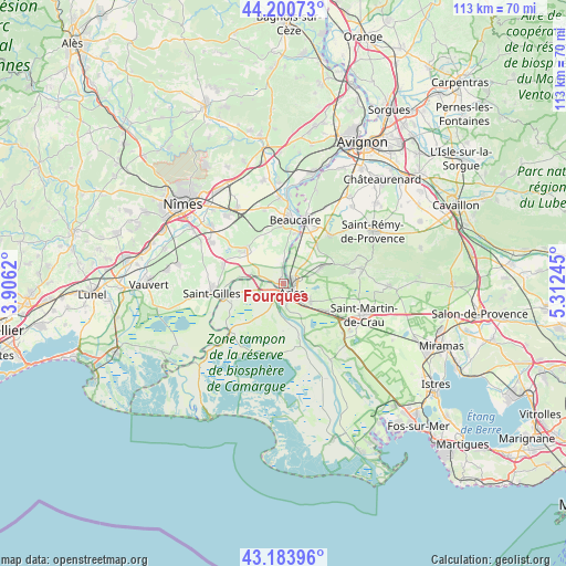
Fourques GPS coordinates[2]
43° 41' 40.2" North, 4° 36' 33.552" East
| Map corner | latitude | longitude |
|---|---|---|
| Upper-left | 44.20073°, | 3.9062° |
| Center: | 43.6945°, | 4.60932° |
| Lower-right: | 43.18396°, | 5.31245° |
| Map W x H: | 113.1×113.1 km | = 70.3×70.3mi |
| max Lat: | 51.07786° ⇑90.5% North |
| Fourques: | 43.6945° |
| min Lat: | ⇓9.5% South 41.3874° |
| min Long | Fourques | max Long |
| -5.08615° | 4.60932° | 9.52242° |
| W 72.9%⇐ | ⇒27.1% E |
Elevation
Elevation of Fourques is 7 m = 23 ft, and this is 186.7 m = 613 ft below average elevation for this country.
| Max E: |
2333 m = 7654 ft | 98.6% |
| Avg. | 193.7 m = 635 ft | |
| Fourques | 7 m = 23 ft | |
Min E: |
-1 m = -3 ft | 1.4% |
See also: France elevation on elevation.city.
Geographical zone
Fourques is located in North temperate zone (between Tropic of Cancer and the Arctic Circle). Distance of this Northern Tropic circle is 2252.5 km =1399.6 mi to South.| Distance of | km | miles | from Fourques |
|---|---|---|---|
| North Pole | 5148.7 | 3199.3 | to North |
| Arctic Circle | 2542.8 | 1580 | to North |
| Tropic Cancer | 2252.5 | 1399.6 | to South |
| Equator | 4858.4 | 3018.9 | to South |


Nearby cities:
15 places around Fourques: (largest is in red/bold)
• Arles
2.6 km =1.6 mi,  139°
139°
• Beaucaire
12.9 km =8 mi,  12°
12°
• Bellegarde
9.9 km =6.2 mi,  311°
311°
• Comps
17.6 km =10.9 mi,  359°
359°
• Fontvieille
8.9 km =5.5 mi,  65°
65°
• Garons
16.8 km =10.4 mi,  299°
299°
• Jonquières-Saint-Vincent
15.3 km =9.5 mi,  346°
346°
• Manduel
17.6 km =10.9 mi,  321°
321°
• Maussane-les-Alpilles
16 km =9.9 mi,  78°
78°
• Paradou
14.4 km =8.9 mi, 80°
• Redessan
17.6 km =10.9 mi,  329°
329°
• Saint-Gilles
14.5 km =9 mi,  262°
262°
• Saint-Martin-de-Crau
17.5 km =10.9 mi,  110°
110°
• Saint-Étienne-du-Grès
13.3 km =8.3 mi,  44°
44°
• Tarascon
13 km =8.1 mi,  18°
18°
Sources, notices
• [Note1] Compared only with cities in France existing in our database
• [Src1] Map data: © OpenStreetMap contributors (CC-BY-SA)
• [Src2] Other city data from geonames.org with taken over terms of usage.
• [Src3] Geographical zone / Annual Mean Temperature by Robert A. Rohde @ Wikipedia
