Saint-Étienne-de-Mer-Morte geodata
Saint-Étienne-de-Mer-Morte (Pays de la Loire) is a populated place; located in France in Europe/Paris (GMT+2) time zone. With population of 1,084 people, there are 8234 cities with bigger population in this country. Compared to other cities in France, 56% of cities are located further ↑North; 93.7% of cities are located further →East and 89.5% of cities have higher elevation than Saint-Étienne-de-Mer-Morte. Note1
Administrative division(s):
- Level 1: Pays de la Loire
- Level 2: Loire-Atlantique
- Level 3: Arrondissement de Nantes
- Level 4: Saint-Étienne-de-Mer-Morte
Current local time in Saint-Étienne-de-Mer-Morte:
04:52 PM, SaturdayDifference from your time zone: hours


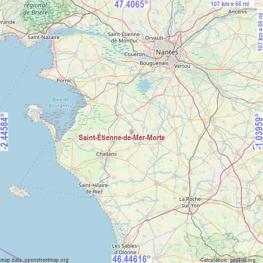
Saint-Étienne-de-Mer-Morte GPS coordinates[2]
46° 55' 42.528" North, 1° 44' 33.792" West
| Map corner | latitude | longitude |
|---|---|---|
| Upper-left | 47.4065°, | -2.44584° |
| Center: | 46.92848°, | -1.74272° |
| Lower-right: | 46.44616°, | -1.03959° |
| Map W x H: | 106.8×106.8 km | = 66.4×66.4mi |
| max Lat: | 51.07786° ⇑56% North |
| Saint-Étienne-de-Mer-Morte: | 46.92848° |
| min Lat: | ⇓44% South 41.3874° |
| min Long | Saint-Étienne- | max Long |
| -5.08615° | -1.74272° | 9.52242° |
| W 6.3%⇐ | ⇒93.7% E |
Elevation
Elevation of Saint-Étienne-de-Mer-Morte is 31 m = 102 ft, and this is 162.7 m = 534 ft below average elevation for this country.
| Max E: |
2333 m = 7654 ft | 89.5% |
| Avg. | 193.7 m = 635 ft | |
| Saint-Étienne-de-Mer-Morte | 31 m = 102 ft | |
Min E: |
-1 m = -3 ft | 10.5% |
See also: France elevation on elevation.city.
Geographical zone
Saint-Étienne-de-Mer-Morte is located in North temperate zone (between Tropic of Cancer and the Arctic Circle). Distance of this North polar circle is 2183.2 km =1356.6 mi to North.| Distance of | km | miles | from Saint-Étienne-de-Mer-Morte |
|---|---|---|---|
| North Pole | 4789.1 | 2975.8 | to North |
| Arctic Circle | 2183.2 | 1356.6 | to North |
| Tropic Cancer | 2612 | 1623 | to South |
| Equator | 5218 | 3242.3 | to South |


Nearby cities:
15 places around Saint-Étienne-de-Mer-Morte: (largest is in red/bold)
• Bois-de-Cené
11 km =6.8 mi,  274°
274°
• Challans
13.8 km =8.6 mi,  226°
226°
• Châteauneuf
13.3 km =8.3 mi, 265°
• Corcoué-sur-Logne
12.8 km =8 mi,  70°
70°
• Falleron
6.1 km =3.8 mi,  149°
149°
• Froidfond
6.7 km =4.2 mi,  189°
189°
• La Garnache
7.9 km =4.9 mi,  238°
238°
• La Limouzinière
13.2 km =8.2 mi,  57°
57°
• Legé
11.8 km =7.3 mi,  114°
114°
• Machecoul
9.5 km =5.9 mi,  319°
319°
• Paulx
3.8 km =2.4 mi,  345°
345°
• Saint-Christophe-du-Ligneron
11.7 km =7.3 mi, 188°
• Saint-Lumine-de-Coutais
14 km =8.7 mi,  4°
4°
• Saint-Même-le-Tenu
10.9 km =6.8 mi,  338°
338°
• Touvois
5.4 km =3.4 mi,  123°
123°
Sources, notices
• [Note1] Compared only with cities in France existing in our database
• [Src1] Map data: © OpenStreetMap contributors (CC-BY-SA)
• [Src2] Other city data from geonames.org with taken over terms of usage.
• [Src3] Geographical zone / Annual Mean Temperature by Robert A. Rohde @ Wikipedia
