Falleron geodata
Falleron (Pays de la Loire) is a populated place; located in France in Europe/Paris (GMT+2) time zone. With population of 1,249 people, there are 7287 cities with bigger population in this country. Compared to other cities in France, 56.4% of cities are located further ↑North; 93.5% of cities are located further →East and 88.3% of cities have higher elevation than Falleron. Note1
Administrative division(s):
- Level 1: Pays de la Loire
- Level 2: Département de la Vendée
- Level 3: Arrondissement de La Roche-sur-Yon
- Level 4: Falleron


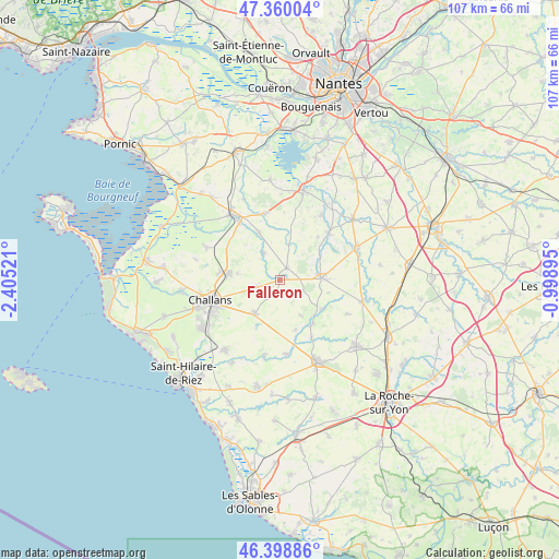
Falleron GPS coordinates[2]
46° 52' 53.76" North, 1° 42' 7.488" West
| Map corner | latitude | longitude |
|---|---|---|
| Upper-left | 47.36004°, | -2.40521° |
| Center: | 46.8816°, | -1.70208° |
| Lower-right: | 46.39886°, | -0.99895° |
| Map W x H: | 106.9×106.9 km | = 66.4×66.4mi |
| max Lat: | 51.07786° ⇑56.4% North |
| Falleron: | 46.8816° |
| min Lat: | ⇓43.6% South 41.3874° |
| min Long | Falleron | max Long |
| -5.08615° | -1.70208° | 9.52242° |
| W 6.5%⇐ | ⇒93.5% E |
Elevation
Elevation of Falleron is 34 m = 112 ft, and this is 159.7 m = 524 ft below average elevation for this country.
| Max E: |
2333 m = 7654 ft | 88.3% |
| Avg. | 193.7 m = 635 ft | |
| Falleron | 34 m = 112 ft | |
Min E: |
-1 m = -3 ft | 11.7% |
See also: France elevation on elevation.city.
Geographical zone
Falleron is located in North temperate zone (between Tropic of Cancer and the Arctic Circle). Distance of this North polar circle is 2188.4 km =1359.8 mi to North.| Distance of | km | miles | from Falleron |
|---|---|---|---|
| North Pole | 4794.3 | 2979 | to North |
| Arctic Circle | 2188.4 | 1359.8 | to North |
| Tropic Cancer | 2606.8 | 1619.8 | to South |
| Equator | 5212.7 | 3239 | to South |


Nearby cities:
15 places around Falleron: (largest is in red/bold)
• Challans
13.8 km =8.6 mi,  252°
252°
• Corcoué-sur-Logne
13.1 km =8.1 mi,  43°
43°
• Froidfond
4.4 km =2.7 mi, 251°
• La Chapelle-Palluau
12.6 km =7.8 mi,  151°
151°
• La Garnache
9.9 km =6.2 mi,  276°
276°
• La Limouzinière
14.7 km =9.1 mi,  32°
32°
• Legé
7.7 km =4.8 mi,  87°
87°
• Maché
14.2 km =8.8 mi,  175°
175°
• Palluau
10.6 km =6.6 mi,  143°
143°
• Paulx
9.8 km =6.1 mi,  335°
335°
• Saint-Christophe-du-Ligneron
8 km =5 mi,  217°
217°
• Saint-Paul-Mont-Penit
9.9 km =6.2 mi,  162°
162°
• Saint-Étienne-de-Mer-Morte
6.1 km =3.8 mi,  329°
329°
• Saint-Étienne-du-Bois
9.8 km =6.1 mi,  125°
125°
• Touvois
2.7 km =1.7 mi, 32°
Sources, notices
• [Note1] Compared only with cities in France existing in our database
• [Src1] Map data: © OpenStreetMap contributors (CC-BY-SA)
• [Src2] Other city data from geonames.org with taken over terms of usage.
• [Src3] Geographical zone / Annual Mean Temperature by Robert A. Rohde @ Wikipedia
