Chaniers geodata
Chaniers (Nouvelle-Aquitaine) is a populated place; located in France in Europe/Paris (GMT+2) time zone. With population of 3,488 people, there are 2789 cities with bigger population in this country. Compared to other cities in France, 70.6% of cities are located further ↑North; 84% of cities are located further →East and 96.7% of cities have higher elevation than Chaniers. Note1
Administrative division(s):
- Level 1: Nouvelle-Aquitaine
- Level 2: Charente-Maritime
- Level 3: Arrondissement de Saintes
- Level 4: Chaniers


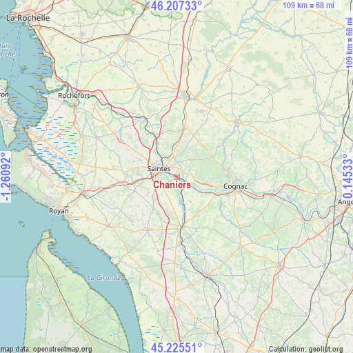
Chaniers GPS coordinates[2]
45° 43' 6.888" North, 0° 33' 28.044" West
| Map corner | latitude | longitude |
|---|---|---|
| Upper-left | 46.20733°, | -1.26092° |
| Center: | 45.71858°, | -0.55779° |
| Lower-right: | 45.22551°, | 0.14533° |
| Map W x H: | 109.2×109.2 km | = 67.9×67.9mi |
| max Lat: | 51.07786° ⇑70.6% North |
| Chaniers: | 45.71858° |
| min Lat: | ⇓29.4% South 41.3874° |
| min Long | Chaniers | max Long |
| -5.08615° | -0.55779° | 9.52242° |
| W 16%⇐ | ⇒84% E |
Elevation
Elevation of Chaniers is 12 m = 39 ft, and this is 181.7 m = 596 ft below average elevation for this country.
| Max E: |
2333 m = 7654 ft | 96.7% |
| Avg. | 193.7 m = 635 ft | |
| Chaniers | 12 m = 39 ft | |
Min E: |
-1 m = -3 ft | 3.3% |
See also: France elevation on elevation.city.
Geographical zone
Chaniers is located in North temperate zone (between Tropic of Cancer and the Arctic Circle). Distance of this North polar circle is 2317.7 km =1440.2 mi to North.| Distance of | km | miles | from Chaniers |
|---|---|---|---|
| North Pole | 4923.6 | 3059.4 | to North |
| Arctic Circle | 2317.7 | 1440.2 | to North |
| Tropic Cancer | 2477.5 | 1539.4 | to South |
| Equator | 5083.4 | 3158.7 | to South |


Nearby cities:
15 places around Chaniers: (largest is in red/bold)
• Bussac-sur-Charente
9.3 km =5.8 mi,  320°
320°
• Chermignac
9.7 km =6 mi,  247°
247°
• Chérac
9.4 km =5.8 mi,  99°
99°
• Courcoury
1.8 km =1.1 mi, 245°
• Fontcouverte
5.8 km =3.6 mi,  337°
337°
• La Chapelle-des-Pots
4.8 km =3 mi,  16°
16°
• Les Gonds
4.4 km =2.7 mi,  263°
263°
• Montils
8.9 km =5.5 mi,  151°
151°
• Saint-Léger
11 km =6.8 mi,  190°
190°
• Saint-Sauvant
4.7 km =2.9 mi,  61°
61°
• Saint-Sever-de-Saintonge
4.9 km =3 mi,  114°
114°
• Saintes
6.7 km =4.2 mi,  296°
296°
• Salignac-sur-Charente
11.2 km =7 mi,  117°
117°
• Thénac
9.4 km =5.8 mi,  232°
232°
• Vénérand
8.3 km =5.2 mi,  0°
0°
Sources, notices
• [Note1] Compared only with cities in France existing in our database
• [Src1] Map data: © OpenStreetMap contributors (CC-BY-SA)
• [Src2] Other city data from geonames.org with taken over terms of usage.
• [Src3] Geographical zone / Annual Mean Temperature by Robert A. Rohde @ Wikipedia
