Vénérand geodata
Vénérand (Nouvelle-Aquitaine) is a populated place; located in France in Europe/Paris (GMT+2) time zone. With population of 642 people, there are 12644 cities with bigger population in this country. Compared to other cities in France, 69.4% of cities are located further ↑North; 84% of cities are located further →East and 72.6% of cities have higher elevation than Vénérand. Note1
Administrative division(s):
- Level 1: Nouvelle-Aquitaine
- Level 2: Charente-Maritime
- Level 3: Arrondissement de Saintes
- Level 4: Vénérand


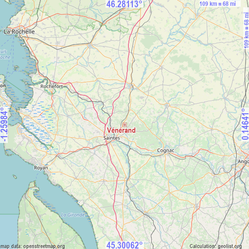
Vénérand GPS coordinates[2]
45° 47' 34.908" North, 0° 33' 24.156" West
| Map corner | latitude | longitude |
|---|---|---|
| Upper-left | 46.28113°, | -1.25984° |
| Center: | 45.79303°, | -0.55671° |
| Lower-right: | 45.30062°, | 0.14641° |
| Map W x H: | 109×109 km | = 67.7×67.7mi |
| max Lat: | 51.07786° ⇑69.4% North |
| Vénérand: | 45.79303° |
| min Lat: | ⇓30.6% South 41.3874° |
| min Long | Vénérand | max Long |
| -5.08615° | -0.55671° | 9.52242° |
| W 16%⇐ | ⇒84% E |
Elevation
Elevation of Vénérand is 72 m = 236 ft, and this is 121.7 m = 399 ft below average elevation for this country.
| Max E: |
2333 m = 7654 ft | 72.6% |
| Avg. | 193.7 m = 635 ft | |
| Vénérand | 72 m = 236 ft | |
Min E: |
-1 m = -3 ft | 27.4% |
See also: France elevation on elevation.city.
Geographical zone
Vénérand is located in North temperate zone (between Tropic of Cancer and the Arctic Circle). Distance of this North polar circle is 2309.5 km =1435.1 mi to North.| Distance of | km | miles | from Vénérand |
|---|---|---|---|
| North Pole | 4915.4 | 3054.3 | to North |
| Arctic Circle | 2309.5 | 1435.1 | to North |
| Tropic Cancer | 2485.8 | 1544.6 | to South |
| Equator | 5091.7 | 3163.8 | to South |


Nearby cities:
15 places around Vénérand: (largest is in red/bold)
• Asnières-la-Giraud
11.1 km =6.9 mi,  14°
14°
• Brizambourg
6.8 km =4.2 mi,  60°
60°
• Burie
10.6 km =6.6 mi,  102°
102°
• Bussac-sur-Charente
6 km =3.7 mi,  259°
259°
• Chaniers
8.3 km =5.2 mi,  180°
180°
• Courcoury
9.2 km =5.7 mi,  190°
190°
• Fontcouverte
3.7 km =2.3 mi,  218°
218°
• La Chapelle-des-Pots
3.9 km =2.4 mi,  161°
161°
• Le Douhet
3.3 km =2.1 mi,  346°
346°
• Les Gonds
9.8 km =6.1 mi,  206°
206°
• Saint-Hilaire-de-Villefranche
6.8 km =4.2 mi,  17°
17°
• Saint-Sauvant
7.3 km =4.5 mi,  146°
146°
• Saintes
8 km =5 mi,  228°
228°
• Taillebourg
8.3 km =5.2 mi,  303°
303°
• Écoyeux
5.1 km =3.2 mi,  50°
50°
Sources, notices
• [Note1] Compared only with cities in France existing in our database
• [Src1] Map data: © OpenStreetMap contributors (CC-BY-SA)
• [Src2] Other city data from geonames.org with taken over terms of usage.
• [Src3] Geographical zone / Annual Mean Temperature by Robert A. Rohde @ Wikipedia
