Le Plessis-Grohan geodata
Le Plessis-Grohan (Normandy) is a populated place; located in France in Europe/Paris (GMT+2) time zone. With population of 711 people, there are 11641 cities with bigger population in this country. Compared to other cities in France, 78.5% of cities are located further ↓South; 67.6% of cities are located further →East and 55% of cities have lower elevation than Le Plessis-Grohan. Note1
Administrative division(s):
- Level 1: Normandy
- Level 2: Département de l'Eure
- Level 3: Arrondissement d’Évreux
- Level 4: Le Plessis-Grohan


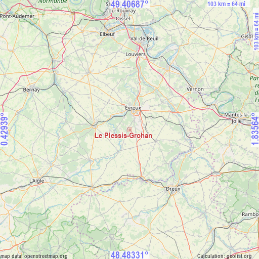
Le Plessis-Grohan GPS coordinates[2]
48° 56' 50.028" North, 1° 7' 57.036" East
| Map corner | latitude | longitude |
|---|---|---|
| Upper-left | 49.40687°, | 0.42939° |
| Center: | 48.94723°, | 1.13251° |
| Lower-right: | 48.48331°, | 1.83564° |
| Map W x H: | 102.7×102.7 km | = 63.8×63.8mi |
| max Lat: | 51.07786° ⇑21.5% North |
| Le Plessis-Grohan: | 48.94723° |
| min Lat: | ⇓78.5% South 41.3874° |
| min Long | Le Plessis-Groh | max Long |
| -5.08615° | 1.13251° | 9.52242° |
| W 32.4%⇐ | ⇒67.6% E |
Elevation
Elevation of Le Plessis-Grohan is 150 m = 492 ft, and this is 43.7 m = 143 ft below average elevation for this country.
| Max E: |
2333 m = 7654 ft | 45% |
| Avg. | 193.7 m = 635 ft | |
| Le Plessis-Grohan | 150 m = 492 ft | |
Min E: |
-1 m = -3 ft | 55% |
See also: France elevation on elevation.city.
Geographical zone
Le Plessis-Grohan is located in North temperate zone (between Tropic of Cancer and the Arctic Circle). Distance of this North polar circle is 1958.8 km =1217.1 mi to North.| Distance of | km | miles | from Le Plessis-Grohan |
|---|---|---|---|
| North Pole | 4564.6 | 2836.3 | to North |
| Arctic Circle | 1958.8 | 1217.1 | to North |
| Tropic Cancer | 2836.5 | 1762.5 | to South |
| Equator | 5442.4 | 3381.7 | to South |


Nearby cities:
15 places around Le Plessis-Grohan: (largest is in red/bold)
• Arnières-sur-Iton
5.9 km =3.7 mi,  339°
339°
• Aulnay-sur-Iton
7.6 km =4.7 mi,  315°
315°
• Caugé
11.2 km =7 mi, 320°
• Damville
9.6 km =6 mi,  206°
206°
• Garencières
9.7 km =6 mi,  84°
84°
• Gauville-la-Campagne
11.3 km =7 mi, 344°
• Glisolles
9.4 km =5.8 mi,  296°
296°
• Guichainville
7.5 km =4.7 mi,  36°
36°
• Huest
11.5 km =7.1 mi,  27°
27°
• La Bonneville-sur-Iton
9.3 km =5.8 mi,  309°
309°
• Le Val-David
9.5 km =5.9 mi,  64°
64°
• Le Vieil-Évreux
10 km =6.2 mi,  50°
50°
• Prey
5.9 km =3.7 mi,  72°
72°
• Saint-Sébastien-de-Morsent
7.8 km =4.8 mi, 335°
• Évreux
8.7 km =5.4 mi,  8°
8°
Sources, notices
• [Note1] Compared only with cities in France existing in our database
• [Src1] Map data: © OpenStreetMap contributors (CC-BY-SA)
• [Src2] Other city data from geonames.org with taken over terms of usage.
• [Src3] Geographical zone / Annual Mean Temperature by Robert A. Rohde @ Wikipedia
