Sainte-Gemme geodata
Sainte-Gemme (Nouvelle-Aquitaine) is a populated place; located in France in Europe/Paris (GMT+2) time zone. With population of 956 people, there are 9159 cities with bigger population in this country. Compared to other cities in France, 69.7% of cities are located further ↑North; 87.2% of cities are located further →East and 86.7% of cities have higher elevation than Sainte-Gemme. Note1
Administrative division(s):
- Level 1: Nouvelle-Aquitaine
- Level 2: Charente-Maritime
- Level 3: Arrondissement de Saintes
- Level 4: Sainte-Gemme


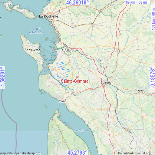
Sainte-Gemme GPS coordinates[2]
45° 46' 18.84" North, 0° 53' 19.968" West
| Map corner | latitude | longitude |
|---|---|---|
| Upper-left | 46.26019°, | -1.59201° |
| Center: | 45.7719°, | -0.88888° |
| Lower-right: | 45.2793°, | -0.18576° |
| Map W x H: | 109.1×109.1 km | = 67.8×67.8mi |
| max Lat: | 51.07786° ⇑69.7% North |
| Sainte-Gemme: | 45.7719° |
| min Lat: | ⇓30.3% South 41.3874° |
| min Long | Sainte-Gemme | max Long |
| -5.08615° | -0.88888° | 9.52242° |
| W 12.8%⇐ | ⇒87.2% E |
Elevation
Elevation of Sainte-Gemme is 38 m = 125 ft, and this is 155.7 m = 511 ft below average elevation for this country.
| Max E: |
2333 m = 7654 ft | 86.7% |
| Avg. | 193.7 m = 635 ft | |
| Sainte-Gemme | 38 m = 125 ft | |
Min E: |
-1 m = -3 ft | 13.3% |
See also: France elevation on elevation.city.
Geographical zone
Sainte-Gemme is located in North temperate zone (between Tropic of Cancer and the Arctic Circle). Distance of this North polar circle is 2311.8 km =1436.5 mi to North.| Distance of | km | miles | from Sainte-Gemme |
|---|---|---|---|
| North Pole | 4917.7 | 3055.7 | to North |
| Arctic Circle | 2311.8 | 1436.5 | to North |
| Tropic Cancer | 2483.4 | 1543.1 | to South |
| Equator | 5089.4 | 3162.4 | to South |


Nearby cities:
15 places around Sainte-Gemme: (largest is in red/bold)
• Beurlay
10.7 km =6.6 mi,  22°
22°
• Champagne
6.8 km =4.2 mi,  347°
347°
• Corme-Royal
6.5 km =4 mi,  118°
118°
• La Gripperie-Saint-Symphorien
4.7 km =2.9 mi,  312°
312°
• Le Gua
6.7 km =4.2 mi,  220°
220°
• Les Essards
10.3 km =6.4 mi,  77°
77°
• Nieul-lès-Saintes
12.3 km =7.6 mi,  96°
96°
• Nieulle-sur-Seudre
9 km =5.6 mi,  254°
254°
• Pont-l’Abbé-d’Arnoult
6.4 km =4 mi,  9°
9°
• Sablonceaux
6.9 km =4.3 mi,  179°
179°
• Saint-Just-Luzac
11.6 km =7.2 mi,  285°
285°
• Saint-Porchaire
9.9 km =6.2 mi,  56°
56°
• Saint-Romain-de-Benet
9.5 km =5.9 mi,  160°
160°
• Saujon
11.4 km =7.1 mi,  194°
194°
• Soulignonne
8 km =5 mi,  85°
85°
Sources, notices
• [Note1] Compared only with cities in France existing in our database
• [Src1] Map data: © OpenStreetMap contributors (CC-BY-SA)
• [Src2] Other city data from geonames.org with taken over terms of usage.
• [Src3] Geographical zone / Annual Mean Temperature by Robert A. Rohde @ Wikipedia
