Sainte-Flaive-des-Loups geodata
Sainte-Flaive-des-Loups (Pays de la Loire) is a populated place; located in France in Europe/Paris (GMT+2) time zone. With population of 1,881 people, there are 5072 cities with bigger population in this country. Compared to other cities in France, 59.1% of cities are located further ↑North; 92.8% of cities are located further →East and 76.2% of cities have higher elevation than Sainte-Flaive-des-Loups. Note1
Administrative division(s):
- Level 1: Pays de la Loire
- Level 2: Département de la Vendée
- Level 3: Arrondissement des Sables-d'Olonne
- Level 4: Sainte-Flaive-des-Loups
Current local time in Sainte-Flaive-des-Loups:
04:52 PM, SaturdayDifference from your time zone: hours


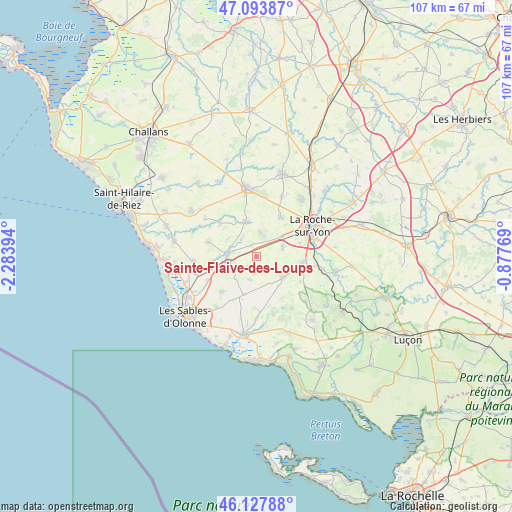
Sainte-Flaive-des-Loups GPS coordinates[2]
46° 36' 46.908" North, 1° 34' 50.952" West
| Map corner | latitude | longitude |
|---|---|---|
| Upper-left | 47.09387°, | -2.28394° |
| Center: | 46.61303°, | -1.58082° |
| Lower-right: | 46.12788°, | -0.87769° |
| Map W x H: | 107.4×107.4 km | = 66.7×66.7mi |
| max Lat: | 51.07786° ⇑59.1% North |
| Sainte-Flaive-des-Loups: | 46.61303° |
| min Lat: | ⇓40.9% South 41.3874° |
| min Long | Sainte-Flaive-d | max Long |
| -5.08615° | -1.58082° | 9.52242° |
| W 7.2%⇐ | ⇒92.8% E |
Elevation
Elevation of Sainte-Flaive-des-Loups is 64 m = 210 ft, and this is 129.7 m = 426 ft below average elevation for this country.
| Max E: |
2333 m = 7654 ft | 76.2% |
| Avg. | 193.7 m = 635 ft | |
| Sainte-Flaive-des-Loups | 64 m = 210 ft | |
Min E: |
-1 m = -3 ft | 23.8% |
See also: France elevation on elevation.city.
Geographical zone
Sainte-Flaive-des-Loups is located in North temperate zone (between Tropic of Cancer and the Arctic Circle). Distance of this North polar circle is 2218.3 km =1378.4 mi to North.| Distance of | km | miles | from Sainte-Flaive-des-Loups |
|---|---|---|---|
| North Pole | 4824.2 | 2997.6 | to North |
| Arctic Circle | 2218.3 | 1378.4 | to North |
| Tropic Cancer | 2577 | 1601.3 | to South |
| Equator | 5182.9 | 3220.5 | to South |


Nearby cities:
15 places around Sainte-Flaive-des-Loups: (largest is in red/bold)
• Aubigny
9.9 km =6.2 mi,  100°
100°
• Beaulieu-sous-la-Roche
7.4 km =4.6 mi,  341°
341°
• Grosbreuil
8.6 km =5.3 mi,  198°
198°
• La Boissière-des-Landes
10.6 km =6.6 mi,  120°
120°
• La Chapelle-Achard
5.8 km =3.6 mi,  241°
241°
• La Mothe-Achard
6 km =3.7 mi,  273°
273°
• Landeronde
5 km =3.1 mi,  9°
9°
• Le Girouard
5.1 km =3.2 mi, 195°
• Les Clouzeaux
5.7 km =3.5 mi,  72°
72°
• Martinet
10.4 km =6.5 mi,  312°
312°
• Nieul-le-Dolent
7.1 km =4.4 mi,  128°
128°
• Saint-Georges-de-Pointindoux
4.7 km =2.9 mi,  318°
318°
• Saint-Julien-des-Landes
10.6 km =6.6 mi,  286°
286°
• Sainte-Foy
10.3 km =6.4 mi,  222°
222°
• Venansault
9.5 km =5.9 mi,  32°
32°
Sources, notices
• [Note1] Compared only with cities in France existing in our database
• [Src1] Map data: © OpenStreetMap contributors (CC-BY-SA)
• [Src2] Other city data from geonames.org with taken over terms of usage.
• [Src3] Geographical zone / Annual Mean Temperature by Robert A. Rohde @ Wikipedia
