Landeronde geodata
Landeronde (Pays de la Loire) is a populated place; located in France in Europe/Paris (GMT+2) time zone. With population of 1,946 people, there are 4920 cities with bigger population in this country. Compared to other cities in France, 58.7% of cities are located further ↑North; 92.7% of cities are located further →East and 79.4% of cities have higher elevation than Landeronde. Note1
Administrative division(s):
- Level 1: Pays de la Loire
- Level 2: Département de la Vendée
- Level 3: Arrondissement des Sables-d'Olonne
- Level 4: Landeronde


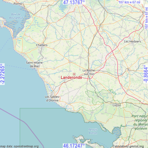
Landeronde GPS coordinates[2]
46° 39' 25.992" North, 1° 34' 10.308" West
| Map corner | latitude | longitude |
|---|---|---|
| Upper-left | 47.13767°, | -2.27265° |
| Center: | 46.65722°, | -1.56953° |
| Lower-right: | 46.17247°, | -0.8664° |
| Map W x H: | 107.3×107.3 km | = 66.7×66.7mi |
| max Lat: | 51.07786° ⇑58.7% North |
| Landeronde: | 46.65722° |
| min Lat: | ⇓41.3% South 41.3874° |
| min Long | Landeronde | max Long |
| -5.08615° | -1.56953° | 9.52242° |
| W 7.3%⇐ | ⇒92.7% E |
Elevation
Elevation of Landeronde is 56 m = 184 ft, and this is 137.7 m = 452 ft below average elevation for this country.
| Max E: |
2333 m = 7654 ft | 79.4% |
| Avg. | 193.7 m = 635 ft | |
| Landeronde | 56 m = 184 ft | |
Min E: |
-1 m = -3 ft | 20.6% |
See also: France elevation on elevation.city.
Geographical zone
Landeronde is located in North temperate zone (between Tropic of Cancer and the Arctic Circle). Distance of this North polar circle is 2213.4 km =1375.3 mi to North.| Distance of | km | miles | from Landeronde |
|---|---|---|---|
| North Pole | 4819.3 | 2994.6 | to North |
| Arctic Circle | 2213.4 | 1375.3 | to North |
| Tropic Cancer | 2581.9 | 1604.3 | to South |
| Equator | 5187.8 | 3223.5 | to South |


Nearby cities:
15 places around Landeronde: (largest is in red/bold)
• Aizenay
9.7 km =6 mi,  342°
342°
• Aubigny
11.1 km =6.9 mi,  127°
127°
• Beaulieu-sous-la-Roche
3.8 km =2.4 mi,  303°
303°
• La Chapelle-Achard
9.7 km =6 mi,  218°
218°
• La Génétouze
9.4 km =5.8 mi,  25°
25°
• La Mothe-Achard
8.3 km =5.2 mi,  236°
236°
• La Roche-sur-Yon
10.4 km =6.5 mi,  84°
84°
• Le Girouard
10.1 km =6.3 mi,  192°
192°
• Les Clouzeaux
5.6 km =3.5 mi,  124°
124°
• Martinet
8.8 km =5.5 mi,  283°
283°
• Mouilleron-le-Captif
11.1 km =6.9 mi,  51°
51°
• Nieul-le-Dolent
10.4 km =6.5 mi,  153°
153°
• Saint-Georges-de-Pointindoux
4.2 km =2.6 mi,  250°
250°
• Sainte-Flaive-des-Loups
5 km =3.1 mi, 189°
• Venansault
5.2 km =3.2 mi, 53°
Sources, notices
• [Note1] Compared only with cities in France existing in our database
• [Src1] Map data: © OpenStreetMap contributors (CC-BY-SA)
• [Src2] Other city data from geonames.org with taken over terms of usage.
• [Src3] Geographical zone / Annual Mean Temperature by Robert A. Rohde @ Wikipedia
