Nieul-le-Dolent geodata
Nieul-le-Dolent (Pays de la Loire) is a populated place; located in France in Europe/Paris (GMT+2) time zone. With population of 1,981 people, there are 4831 cities with bigger population in this country. Compared to other cities in France, 59.5% of cities are located further ↑North; 92.3% of cities are located further →East and 73.6% of cities have higher elevation than Nieul-le-Dolent. Note1
Administrative division(s):
- Level 1: Pays de la Loire
- Level 2: Département de la Vendée
- Level 3: Arrondissement des Sables-d'Olonne
- Level 4: Nieul-le-Dolent


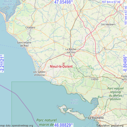
Nieul-le-Dolent GPS coordinates[2]
46° 34' 25.644" North, 1° 30' 29.088" West
| Map corner | latitude | longitude |
|---|---|---|
| Upper-left | 47.05498°, | -2.21121° |
| Center: | 46.57379°, | -1.50808° |
| Lower-right: | 46.08829°, | -0.80496° |
| Map W x H: | 107.5×107.5 km | = 66.8×66.8mi |
| max Lat: | 51.07786° ⇑59.5% North |
| Nieul-le-Dolent: | 46.57379° |
| min Lat: | ⇓40.5% South 41.3874° |
| min Long | Nieul-le-Dolent | max Long |
| -5.08615° | -1.50808° | 9.52242° |
| W 7.7%⇐ | ⇒92.3% E |
Elevation
Elevation of Nieul-le-Dolent is 70 m = 230 ft, and this is 123.7 m = 406 ft below average elevation for this country.
| Max E: |
2333 m = 7654 ft | 73.6% |
| Avg. | 193.7 m = 635 ft | |
| Nieul-le-Dolent | 70 m = 230 ft | |
Min E: |
-1 m = -3 ft | 26.4% |
See also: France elevation on elevation.city.
Geographical zone
Nieul-le-Dolent is located in North temperate zone (between Tropic of Cancer and the Arctic Circle). Distance of this North polar circle is 2222.7 km =1381.1 mi to North.| Distance of | km | miles | from Nieul-le-Dolent |
|---|---|---|---|
| North Pole | 4828.5 | 3000.3 | to North |
| Arctic Circle | 2222.7 | 1381.1 | to North |
| Tropic Cancer | 2572.6 | 1598.5 | to South |
| Equator | 5178.5 | 3217.8 | to South |


Nearby cities:
15 places around Nieul-le-Dolent: (largest is in red/bold)
• Aubigny
4.9 km =3 mi,  58°
58°
• Avrillé
11.9 km =7.4 mi,  169°
169°
• Grosbreuil
9.1 km =5.7 mi,  245°
245°
• La Boissière-des-Landes
3.7 km =2.3 mi,  107°
107°
• La Chapelle-Achard
10.8 km =6.7 mi,  278°
278°
• La Roche-sur-Yon
11.8 km =7.3 mi,  28°
28°
• Landeronde
10.4 km =6.5 mi,  333°
333°
• Le Girouard
7 km =4.3 mi,  265°
265°
• Les Clouzeaux
6.1 km =3.8 mi,  359°
359°
• Moutiers-les-Mauxfaits
12.3 km =7.6 mi,  145°
145°
• Nesmy
8.4 km =5.2 mi,  77°
77°
• Saint-Avaugourd-des-Landes
7 km =4.3 mi, 165°
• Saint-Georges-de-Pointindoux
11.7 km =7.3 mi,  312°
312°
• Saint-Vincent-sur-Graon
11.1 km =6.9 mi,  124°
124°
• Sainte-Flaive-des-Loups
7.1 km =4.4 mi, 308°
Sources, notices
• [Note1] Compared only with cities in France existing in our database
• [Src1] Map data: © OpenStreetMap contributors (CC-BY-SA)
• [Src2] Other city data from geonames.org with taken over terms of usage.
• [Src3] Geographical zone / Annual Mean Temperature by Robert A. Rohde @ Wikipedia
