Chantonnay geodata
Chantonnay (Pays de la Loire) is a populated place; located in France in Europe/Paris (GMT+2) time zone. With population of 8,375 people, there are 1157 cities with bigger population in this country. Compared to other cities in France, 58.3% of cities are located further ↑North; 88.6% of cities are located further →East and 77.3% of cities have higher elevation than Chantonnay. Note1
Administrative division(s):
- Level 1: Pays de la Loire
- Level 2: Département de la Vendée
- Level 3: Arrondissement de La Roche-sur-Yon
- Level 4: Chantonnay


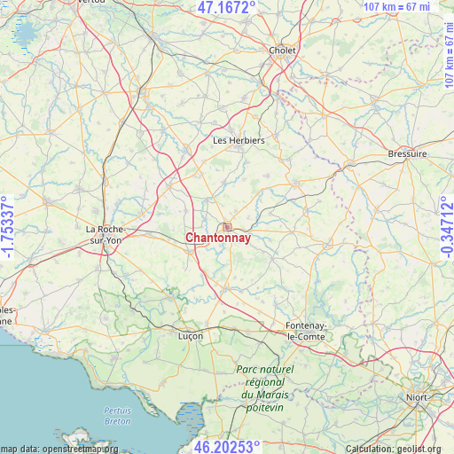
Chantonnay GPS coordinates[2]
46° 41' 13.272" North, 1° 3' 0.864" West
| Map corner | latitude | longitude |
|---|---|---|
| Upper-left | 47.1672°, | -1.75337° |
| Center: | 46.68702°, | -1.05024° |
| Lower-right: | 46.20253°, | -0.34712° |
| Map W x H: | 107.3×107.3 km | = 66.7×66.7mi |
| max Lat: | 51.07786° ⇑58.3% North |
| Chantonnay: | 46.68702° |
| min Lat: | ⇓41.7% South 41.3874° |
| min Long | Chantonnay | max Long |
| -5.08615° | -1.05024° | 9.52242° |
| W 11.4%⇐ | ⇒88.6% E |
Elevation
Elevation of Chantonnay is 61 m = 200 ft, and this is 132.7 m = 435 ft below average elevation for this country.
| Max E: |
2333 m = 7654 ft | 77.3% |
| Avg. | 193.7 m = 635 ft | |
| Chantonnay | 61 m = 200 ft | |
Min E: |
-1 m = -3 ft | 22.7% |
See also: France elevation on elevation.city.
Geographical zone
Chantonnay is located in North temperate zone (between Tropic of Cancer and the Arctic Circle). Distance of this North polar circle is 2210.1 km =1373.3 mi to North.| Distance of | km | miles | from Chantonnay |
|---|---|---|---|
| North Pole | 4816 | 2992.5 | to North |
| Arctic Circle | 2210.1 | 1373.3 | to North |
| Tropic Cancer | 2585.2 | 1606.4 | to South |
| Equator | 5191.1 | 3225.6 | to South |


Nearby cities:
15 places around Chantonnay: (largest is in red/bold)
• Bazoges-en-Pareds
10.7 km =6.6 mi,  108°
108°
• Bournezeau
10.8 km =6.7 mi,  238°
238°
• Chavagnes-les-Redoux
10.5 km =6.5 mi,  72°
72°
• La Jaudonnière
8.3 km =5.2 mi,  125°
125°
• La Réorthe
8.9 km =5.5 mi,  179°
179°
• Monsireigne
10 km =6.2 mi,  50°
50°
• Mouchamps
10.5 km =6.5 mi,  355°
355°
• Rochetrejoux
12.1 km =7.5 mi,  20°
20°
• Saint-Germain-de-Prinçay
4.4 km =2.7 mi,  30°
30°
• Saint-Hilaire-le-Vouhis
6.1 km =3.8 mi,  270°
270°
• Saint-Martin-des-Noyers
10.4 km =6.5 mi,  292°
292°
• Saint-Prouant
10.6 km =6.6 mi,  41°
41°
• Saint-Vincent-Sterlanges
6.6 km =4.1 mi,  333°
333°
• Sainte-Cécile
7.9 km =4.9 mi,  321°
321°
• Sigournais
5.4 km =3.4 mi, 65°
Sources, notices
• [Note1] Compared only with cities in France existing in our database
• [Src1] Map data: © OpenStreetMap contributors (CC-BY-SA)
• [Src2] Other city data from geonames.org with taken over terms of usage.
• [Src3] Geographical zone / Annual Mean Temperature by Robert A. Rohde @ Wikipedia
