Sainte-Austreberthe geodata
Sainte-Austreberthe (Normandy) is a populated place; located in France in Europe/Paris (GMT+2) time zone. With population of 595 people, there are 13406 cities with bigger population in this country. Compared to other cities in France, 90.5% of cities are located further ↓South; 69% of cities are located further →East and 62.8% of cities have higher elevation than Sainte-Austreberthe. Note1
Administrative division(s):
- Level 1: Normandy
- Level 2: Seine-Maritime
- Level 3: Arrondissement de Rouen
- Level 4: Sainte-Austreberthe


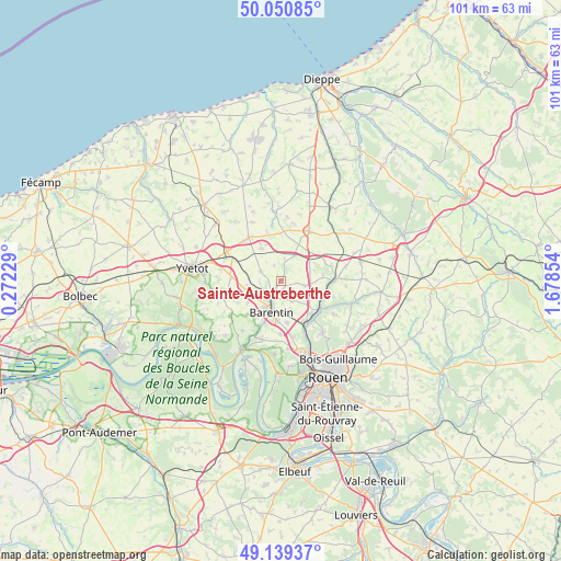
Sainte-Austreberthe GPS coordinates[2]
49° 35' 50.064" North, 0° 58' 31.476" East
| Map corner | latitude | longitude |
|---|---|---|
| Upper-left | 50.05085°, | 0.27229° |
| Center: | 49.59724°, | 0.97541° |
| Lower-right: | 49.13937°, | 1.67854° |
| Map W x H: | 101.3×101.3 km | = 62.9×62.9mi |
| max Lat: | 51.07786° ⇑9.5% North |
| Sainte-Austreberthe: | 49.59724° |
| min Lat: | ⇓90.5% South 41.3874° |
| min Long | Sainte-Austrebe | max Long |
| -5.08615° | 0.97541° | 9.52242° |
| W 31%⇐ | ⇒69% E |
Elevation
Elevation of Sainte-Austreberthe is 95 m = 312 ft, and this is 98.7 m = 324 ft below average elevation for this country.
| Max E: |
2333 m = 7654 ft | 62.8% |
| Avg. | 193.7 m = 635 ft | |
| Sainte-Austreberthe | 95 m = 312 ft | |
Min E: |
-1 m = -3 ft | 37.2% |
See also: France elevation on elevation.city.
Geographical zone
Sainte-Austreberthe is located in North temperate zone (between Tropic of Cancer and the Arctic Circle). Distance of this North polar circle is 1886.5 km =1172.2 mi to North.| Distance of | km | miles | from Sainte-Austreberthe |
|---|---|---|---|
| North Pole | 4492.4 | 2791.4 | to North |
| Arctic Circle | 1886.5 | 1172.2 | to North |
| Tropic Cancer | 2908.8 | 1807.4 | to South |
| Equator | 5514.7 | 3426.7 | to South |


Nearby cities:
15 places around Sainte-Austreberthe: (largest is in red/bold)
• Anceaumeville
6.1 km =3.8 mi,  117°
117°
• Barentin
6 km =3.7 mi,  194°
194°
• Blacqueville
8.7 km =5.4 mi,  243°
243°
• Bouville
7 km =4.3 mi, 235°
• Eslettes
7.9 km =4.9 mi,  133°
133°
• La Houssaye-Béranger
8.7 km =5.4 mi,  62°
62°
• Le Bocasse
7.8 km =4.8 mi,  87°
87°
• Limésy
4 km =2.5 mi,  295°
295°
• Mesnil-Panneville
6 km =3.7 mi,  262°
262°
• Pavilly
3.7 km =2.3 mi,  204°
204°
• Pissy-Pôville
7.6 km =4.7 mi,  170°
170°
• Saint-Ouen-du-Breuil
5.2 km =3.2 mi,  28°
28°
• Sierville
4.4 km =2.7 mi,  101°
101°
• Villers-Écalles
7.4 km =4.6 mi,  213°
213°
• Émanville
3 km =1.9 mi,  338°
338°
Sources, notices
• [Note1] Compared only with cities in France existing in our database
• [Src1] Map data: © OpenStreetMap contributors (CC-BY-SA)
• [Src2] Other city data from geonames.org with taken over terms of usage.
• [Src3] Geographical zone / Annual Mean Temperature by Robert A. Rohde @ Wikipedia
