Eslettes geodata
Eslettes (Normandy) is a populated place; located in France in Europe/Paris (GMT+2) time zone. With population of 1,431 people, there are 6477 cities with bigger population in this country. Compared to other cities in France, 90% of cities are located further ↓South; 68.2% of cities are located further →East and 54.2% of cities have lower elevation than Eslettes. Note1
Administrative division(s):
- Level 1: Normandy
- Level 2: Seine-Maritime
- Level 3: Arrondissement de Rouen
- Level 4: Eslettes


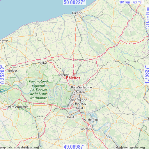
Eslettes GPS coordinates[2]
49° 32' 53.52" North, 1° 3' 18.54" East
| Map corner | latitude | longitude |
|---|---|---|
| Upper-left | 50.00227°, | 0.35202° |
| Center: | 49.5482°, | 1.05515° |
| Lower-right: | 49.08987°, | 1.75827° |
| Map W x H: | 101.4×101.4 km | = 63×63mi |
| max Lat: | 51.07786° ⇑10% North |
| Eslettes: | 49.5482° |
| min Lat: | ⇓90% South 41.3874° |
| min Long | Eslettes | max Long |
| -5.08615° | 1.05515° | 9.52242° |
| W 31.8%⇐ | ⇒68.2% E |
Elevation
Elevation of Eslettes is 147 m = 482 ft, and this is 46.7 m = 153 ft below average elevation for this country.
| Max E: |
2333 m = 7654 ft | 45.8% |
| Avg. | 193.7 m = 635 ft | |
| Eslettes | 147 m = 482 ft | |
Min E: |
-1 m = -3 ft | 54.2% |
See also: France elevation on elevation.city.
Geographical zone
Eslettes is located in North temperate zone (between Tropic of Cancer and the Arctic Circle). Distance of this North polar circle is 1891.9 km =1175.6 mi to North.| Distance of | km | miles | from Eslettes |
|---|---|---|---|
| North Pole | 4497.8 | 2794.8 | to North |
| Arctic Circle | 1891.9 | 1175.6 | to North |
| Tropic Cancer | 2903.3 | 1804 | to South |
| Equator | 5509.2 | 3423.3 | to South |


Nearby cities:
15 places around Eslettes: (largest is in red/bold)
• Anceaumeville
2.6 km =1.6 mi,  352°
352°
• Barentin
7.2 km =4.5 mi,  267°
267°
• Bosc-Guérard-Saint-Adrien
4.5 km =2.8 mi,  99°
99°
• Clères
7.3 km =4.5 mi,  37°
37°
• Houppeville
4.3 km =2.7 mi,  155°
155°
• Le Bocasse
6.1 km =3.8 mi,  19°
19°
• Le Houlme
4.5 km =2.8 mi,  198°
198°
• Malaunay
2.5 km =1.6 mi, 200°
• Mont-Cauvaire
4.7 km =2.9 mi,  57°
57°
• Notre-Dame-de-Bondeville
7.2 km =4.5 mi,  182°
182°
• Pavilly
7.6 km =4.7 mi,  286°
286°
• Pissy-Pôville
4.9 km =3 mi,  245°
245°
• Roumare
7.2 km =4.5 mi,  234°
234°
• Saint-Jean-du-Cardonnay
5.8 km =3.6 mi,  213°
213°
• Sierville
4.8 km =3 mi,  342°
342°
Sources, notices
• [Note1] Compared only with cities in France existing in our database
• [Src1] Map data: © OpenStreetMap contributors (CC-BY-SA)
• [Src2] Other city data from geonames.org with taken over terms of usage.
• [Src3] Geographical zone / Annual Mean Temperature by Robert A. Rohde @ Wikipedia
