Sainte-Anne-sur-Brivet geodata
Sainte-Anne-sur-Brivet (Pays de la Loire) is a populated place; located in France in Europe/Paris (GMT+2) time zone. With population of 2,086 people, there are 4620 cities with bigger population in this country. Compared to other cities in France, 50.6% of cities are located further ↓South; 94.9% of cities are located further →East and 94.4% of cities have higher elevation than Sainte-Anne-sur-Brivet. Note1
Administrative division(s):
- Level 1: Pays de la Loire
- Level 2: Loire-Atlantique
- Level 3: Arrondissement de Saint-Nazaire
- Level 4: Sainte-Anne-sur-Brivet


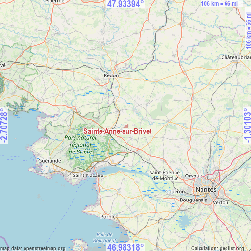
Sainte-Anne-sur-Brivet GPS coordinates[2]
47° 27' 38.556" North, 2° 0' 14.94" West
| Map corner | latitude | longitude |
|---|---|---|
| Upper-left | 47.93394°, | -2.70728° |
| Center: | 47.46071°, | -2.00415° |
| Lower-right: | 46.98318°, | -1.30103° |
| Map W x H: | 105.7×105.7 km | = 65.7×65.7mi |
| max Lat: | 51.07786° ⇑49.4% North |
| Sainte-Anne-sur-Brivet: | 47.46071° |
| min Lat: | ⇓50.6% South 41.3874° |
| min Long | Sainte-Anne-sur | max Long |
| -5.08615° | -2.00415° | 9.52242° |
| W 5.1%⇐ | ⇒94.9% E |
Elevation
Elevation of Sainte-Anne-sur-Brivet is 19 m = 62 ft, and this is 174.7 m = 573 ft below average elevation for this country.
| Max E: |
2333 m = 7654 ft | 94.4% |
| Avg. | 193.7 m = 635 ft | |
| Sainte-Anne-sur-Brivet | 19 m = 62 ft | |
Min E: |
-1 m = -3 ft | 5.6% |
See also: France elevation on elevation.city.
Geographical zone
Sainte-Anne-sur-Brivet is located in North temperate zone (between Tropic of Cancer and the Arctic Circle). Distance of this North polar circle is 2124 km =1319.8 mi to North.| Distance of | km | miles | from Sainte-Anne-sur-Brivet |
|---|---|---|---|
| North Pole | 4729.9 | 2939 | to North |
| Arctic Circle | 2124 | 1319.8 | to North |
| Tropic Cancer | 2671.2 | 1659.8 | to South |
| Equator | 5277.1 | 3279 | to South |


Nearby cities:
15 places around Sainte-Anne-sur-Brivet: (largest is in red/bold)
• Besné
9.3 km =5.8 mi,  223°
223°
• Bouvron
12.8 km =8 mi,  112°
112°
• Campbon
5.9 km =3.7 mi,  153°
153°
• Crossac
13.6 km =8.5 mi,  246°
246°
• Drefféac
4.3 km =2.7 mi,  291°
291°
• Guenrouet
7.5 km =4.7 mi,  30°
30°
• La Chapelle-Launay
10.2 km =6.3 mi,  165°
165°
• Missillac
11.9 km =7.4 mi,  281°
281°
• Plessé
12.6 km =7.8 mi,  44°
44°
• Pontchâteau
6.9 km =4.3 mi, 248°
• Prinquiau
11 km =6.8 mi,  182°
182°
• Quilly
3.9 km =2.4 mi,  89°
89°
• Saint-Gildas-des-Bois
6.6 km =4.1 mi,  338°
338°
• Savenay
12.1 km =7.5 mi,  157°
157°
• Sévérac
11.3 km =7 mi,  331°
331°
Sources, notices
• [Note1] Compared only with cities in France existing in our database
• [Src1] Map data: © OpenStreetMap contributors (CC-BY-SA)
• [Src2] Other city data from geonames.org with taken over terms of usage.
• [Src3] Geographical zone / Annual Mean Temperature by Robert A. Rohde @ Wikipedia
