Besné geodata
Besné (Pays de la Loire) is a populated place; located in France in Europe/Paris (GMT+2) time zone. With population of 2,212 people, there are 4343 cities with bigger population in this country. Compared to other cities in France, 50.1% of cities are located further ↑North; 95.2% of cities are located further →East and 98.6% of cities have higher elevation than Besné. Note1
Administrative division(s):
- Level 1: Pays de la Loire
- Level 2: Loire-Atlantique
- Level 3: Arrondissement de Saint-Nazaire
- Level 4: Besné


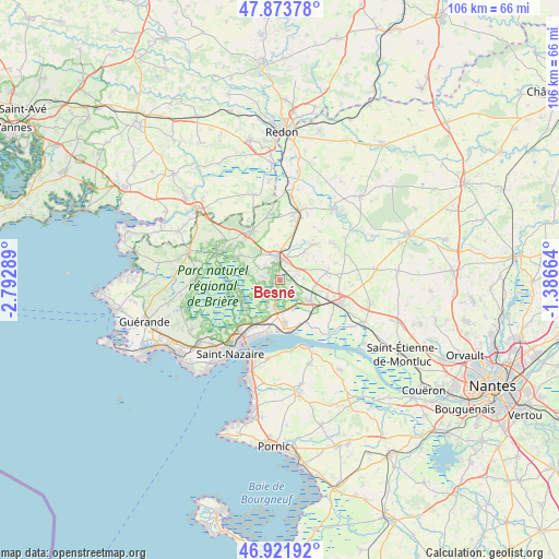
Besné GPS coordinates[2]
47° 24' 0" North, 2° 5' 23.136" West
| Map corner | latitude | longitude |
|---|---|---|
| Upper-left | 47.87378°, | -2.79289° |
| Center: | 47.4°, | -2.08976° |
| Lower-right: | 46.92192°, | -1.38664° |
| Map W x H: | 105.8×105.8 km | = 65.7×65.7mi |
| max Lat: | 51.07786° ⇑50.1% North |
| Besné: | 47.4° |
| min Lat: | ⇓49.9% South 41.3874° |
| min Long | Besné | max Long |
| -5.08615° | -2.08976° | 9.52242° |
| W 4.8%⇐ | ⇒95.2% E |
Elevation
Elevation of Besné is 7 m = 23 ft, and this is 186.7 m = 613 ft below average elevation for this country.
| Max E: |
2333 m = 7654 ft | 98.6% |
| Avg. | 193.7 m = 635 ft | |
| Besné | 7 m = 23 ft | |
Min E: |
-1 m = -3 ft | 1.4% |
See also: France elevation on elevation.city.
Geographical zone
Besné is located in North temperate zone (between Tropic of Cancer and the Arctic Circle). Distance of this North polar circle is 2130.8 km =1324 mi to North.| Distance of | km | miles | from Besné |
|---|---|---|---|
| North Pole | 4736.7 | 2943.2 | to North |
| Arctic Circle | 2130.8 | 1324 | to North |
| Tropic Cancer | 2664.5 | 1655.6 | to South |
| Equator | 5270.4 | 3274.9 | to South |


Nearby cities:
15 places around Besné: (largest is in red/bold)
• Campbon
9.2 km =5.7 mi,  80°
80°
• Crossac
6.1 km =3.8 mi,  281°
281°
• Donges
9.2 km =5.7 mi,  173°
173°
• Drefféac
8.6 km =5.3 mi,  16°
16°
• La Chapelle-Launay
9.5 km =5.9 mi,  108°
108°
• Le Pin
8 km =5 mi,  226°
226°
• Missillac
10.5 km =6.5 mi,  329°
329°
• Montoir-de-Bretagne
9 km =5.6 mi,  210°
210°
• Pontchâteau
4.2 km =2.6 mi,  359°
359°
• Prinquiau
7.4 km =4.6 mi,  124°
124°
• Saint-Joachim
7.9 km =4.9 mi,  256°
256°
• Saint-Malo-de-Guersac
8.4 km =5.2 mi, 231°
• Sainte-Anne-sur-Brivet
9.3 km =5.8 mi,  43°
43°
• Sainte-Reine-de-Bretagne
9 km =5.6 mi,  300°
300°
• Trignac
11.8 km =7.3 mi,  219°
219°
Sources, notices
• [Note1] Compared only with cities in France existing in our database
• [Src1] Map data: © OpenStreetMap contributors (CC-BY-SA)
• [Src2] Other city data from geonames.org with taken over terms of usage.
• [Src3] Geographical zone / Annual Mean Temperature by Robert A. Rohde @ Wikipedia
