Bonneuil-Matours geodata
Bonneuil-Matours (Nouvelle-Aquitaine) is a populated place; located in France in Europe/Paris (GMT+2) time zone. With population of 1,927 people, there are 4969 cities with bigger population in this country. Compared to other cities in France, 58.4% of cities are located further ↑North; 72.7% of cities are located further →East and 77% of cities have higher elevation than Bonneuil-Matours. Note1
Administrative division(s):
- Level 1: Nouvelle-Aquitaine
- Level 2: Vienne
- Level 3: Arrondissement de Châtellerault
- Level 4: Bonneuil-Matours


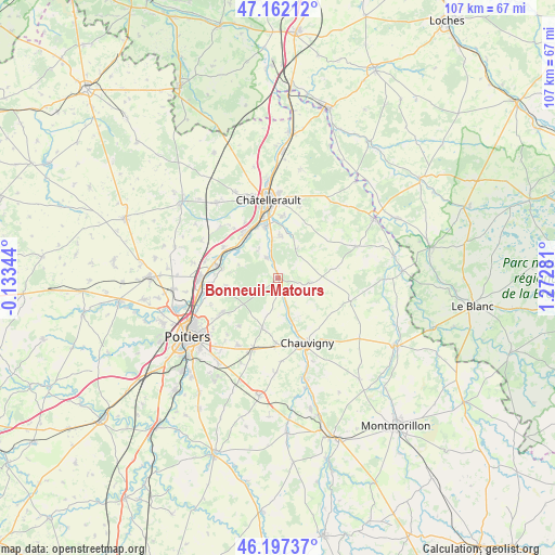
Bonneuil-Matours GPS coordinates[2]
46° 40' 54.84" North, 0° 34' 10.848" East
| Map corner | latitude | longitude |
|---|---|---|
| Upper-left | 47.16212°, | -0.13344° |
| Center: | 46.6819°, | 0.56968° |
| Lower-right: | 46.19737°, | 1.27281° |
| Map W x H: | 107.3×107.3 km | = 66.7×66.7mi |
| max Lat: | 51.07786° ⇑58.4% North |
| Bonneuil-Matours: | 46.6819° |
| min Lat: | ⇓41.6% South 41.3874° |
| min Long | Bonneuil-Matour | max Long |
| -5.08615° | 0.56968° | 9.52242° |
| W 27.3%⇐ | ⇒72.7% E |
Elevation
Elevation of Bonneuil-Matours is 62 m = 203 ft, and this is 131.7 m = 432 ft below average elevation for this country.
| Max E: |
2333 m = 7654 ft | 77% |
| Avg. | 193.7 m = 635 ft | |
| Bonneuil-Matours | 62 m = 203 ft | |
Min E: |
-1 m = -3 ft | 23% |
See also: France elevation on elevation.city.
Geographical zone
Bonneuil-Matours is located in North temperate zone (between Tropic of Cancer and the Arctic Circle). Distance of this North polar circle is 2210.6 km =1373.6 mi to North.| Distance of | km | miles | from Bonneuil-Matours |
|---|---|---|---|
| North Pole | 4816.5 | 2992.8 | to North |
| Arctic Circle | 2210.6 | 1373.6 | to North |
| Tropic Cancer | 2584.6 | 1606 | to South |
| Equator | 5190.5 | 3225.2 | to South |


Nearby cities:
15 places around Bonneuil-Matours: (largest is in red/bold)
• Archigny
6.4 km =4 mi,  98°
98°
• Beaumont
12.3 km =7.6 mi,  299°
299°
• Bignoux
11.9 km =7.4 mi,  219°
219°
• Bonnes
8.8 km =5.5 mi,  167°
167°
• Buxerolles
9.8 km =6.1 mi, 222°
• Cenon-sur-Vienne
10.6 km =6.6 mi,  346°
346°
• Dissay
10.7 km =6.6 mi,  281°
281°
• La Chapelle-Moulière
3.5 km =2.2 mi,  185°
185°
• Lavoux
10 km =6.2 mi,  197°
197°
• Liniers
8.3 km =5.2 mi, 197°
• Monthoiron
6.9 km =4.3 mi,  33°
33°
• Naintré
11.2 km =7 mi,  323°
323°
• Saint-Cyr
10.6 km =6.6 mi,  292°
292°
• Senillé
11.3 km =7 mi,  17°
17°
• Vouneuil-sur-Vienne
4.6 km =2.9 mi,  330°
330°
Sources, notices
• [Note1] Compared only with cities in France existing in our database
• [Src1] Map data: © OpenStreetMap contributors (CC-BY-SA)
• [Src2] Other city data from geonames.org with taken over terms of usage.
• [Src3] Geographical zone / Annual Mean Temperature by Robert A. Rohde @ Wikipedia
