Saint-Clair-sur-Epte geodata
Saint-Clair-sur-Epte (Île-de-France) is a populated place; located in France in Europe/Paris (GMT+2) time zone. With population of 847 people, there are 10113 cities with bigger population in this country. Compared to other cities in France, 84.4% of cities are located further ↓South; 60.7% of cities are located further →East and 84.1% of cities have higher elevation than Saint-Clair-sur-Epte. Note1
Administrative division(s):
- Level 1: Île-de-France
- Level 2: Département du Val-d’Oise
- Level 3: Arrondissement de Pontoise
- Level 4: Saint-Clair-sur-Epte


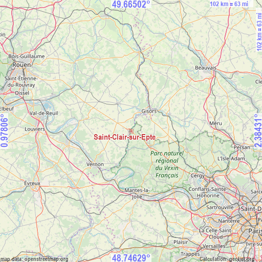
Saint-Clair-sur-Epte GPS coordinates[2]
49° 12' 28.044" North, 1° 40' 52.248" East
| Map corner | latitude | longitude |
|---|---|---|
| Upper-left | 49.66502°, | 0.97806° |
| Center: | 49.20779°, | 1.68118° |
| Lower-right: | 48.74629°, | 2.38431° |
| Map W x H: | 102.2×102.2 km | = 63.5×63.5mi |
| max Lat: | 51.07786° ⇑15.6% North |
| Saint-Clair-sur-Epte: | 49.20779° |
| min Lat: | ⇓84.4% South 41.3874° |
| min Long | Saint-Clair-sur | max Long |
| -5.08615° | 1.68118° | 9.52242° |
| W 39.3%⇐ | ⇒60.7% E |
Elevation
Elevation of Saint-Clair-sur-Epte is 44 m = 144 ft, and this is 149.7 m = 491 ft below average elevation for this country.
| Max E: |
2333 m = 7654 ft | 84.1% |
| Avg. | 193.7 m = 635 ft | |
| Saint-Clair-sur-Epte | 44 m = 144 ft | |
Min E: |
-1 m = -3 ft | 15.9% |
See also: France elevation on elevation.city.
Geographical zone
Saint-Clair-sur-Epte is located in North temperate zone (between Tropic of Cancer and the Arctic Circle). Distance of this North polar circle is 1929.8 km =1199.1 mi to North.| Distance of | km | miles | from Saint-Clair-sur-Epte |
|---|---|---|---|
| North Pole | 4535.7 | 2818.4 | to North |
| Arctic Circle | 1929.8 | 1199.1 | to North |
| Tropic Cancer | 2865.5 | 1780.5 | to South |
| Equator | 5471.4 | 3399.8 | to South |


Nearby cities:
15 places around Saint-Clair-sur-Epte: (largest is in red/bold)
• Bray-et-Lû
8 km =5 mi,  193°
193°
• Bézu-Saint-Éloi
9.9 km =6.2 mi,  9°
9°
• Chaussy
9.6 km =6 mi,  175°
175°
• Château-sur-Epte
1.8 km =1.1 mi,  231°
231°
• Courcelles-lès-Gisors
7.3 km =4.5 mi,  37°
37°
• Dangu
5.1 km =3.2 mi, 11°
• Fourges
10.1 km =6.3 mi,  197°
197°
• Genainville
9.7 km =6 mi,  148°
148°
• Les Thilliers-en-Vexin
6.4 km =4 mi,  300°
300°
• Magny-en-Vexin
9.6 km =6 mi,  127°
127°
• Montagny-en-Vexin
8.8 km =5.5 mi,  98°
98°
• Neaufles-Saint-Martin
8.4 km =5.2 mi,  23°
23°
• Saint-Gervais
7.7 km =4.8 mi,  122°
122°
• Vesly
4.4 km =2.7 mi,  332°
332°
• Écos
5.1 km =3.2 mi,  206°
206°
Sources, notices
• [Note1] Compared only with cities in France existing in our database
• [Src1] Map data: © OpenStreetMap contributors (CC-BY-SA)
• [Src2] Other city data from geonames.org with taken over terms of usage.
• [Src3] Geographical zone / Annual Mean Temperature by Robert A. Rohde @ Wikipedia
