Château-sur-Epte geodata
Château-sur-Epte (Normandy) is a populated place; located in France in Europe/Paris (GMT+2) time zone. With population of 693 people, there are 11901 cities with bigger population in this country. Compared to other cities in France, 84.2% of cities are located further ↓South; 60.9% of cities are located further →East and 65.6% of cities have higher elevation than Château-sur-Epte. Note1
Administrative division(s):
- Level 1: Normandy
- Level 2: Département de l'Eure
- Level 3: Les Andelys
- Level 4: Château-sur-Epte


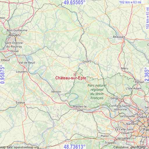
Château-sur-Epte GPS coordinates[2]
49° 11' 51.792" North, 1° 39' 42.732" East
| Map corner | latitude | longitude |
|---|---|---|
| Upper-left | 49.65505°, | 0.95875° |
| Center: | 49.19772°, | 1.66187° |
| Lower-right: | 48.73613°, | 2.365° |
| Map W x H: | 102.2×102.2 km | = 63.5×63.5mi |
| max Lat: | 51.07786° ⇑15.8% North |
| Château-sur-Epte: | 49.19772° |
| min Lat: | ⇓84.2% South 41.3874° |
| min Long | Château-sur-Ep | max Long |
| -5.08615° | 1.66187° | 9.52242° |
| W 39.1%⇐ | ⇒60.9% E |
Elevation
Elevation of Château-sur-Epte is 88 m = 289 ft, and this is 105.7 m = 347 ft below average elevation for this country.
| Max E: |
2333 m = 7654 ft | 65.6% |
| Avg. | 193.7 m = 635 ft | |
| Château-sur-Epte | 88 m = 289 ft | |
Min E: |
-1 m = -3 ft | 34.4% |
See also: France elevation on elevation.city.
Geographical zone
Château-sur-Epte is located in North temperate zone (between Tropic of Cancer and the Arctic Circle). Distance of this North polar circle is 1930.9 km =1199.8 mi to North.| Distance of | km | miles | from Château-sur-Epte |
|---|---|---|---|
| North Pole | 4536.8 | 2819 | to North |
| Arctic Circle | 1930.9 | 1199.8 | to North |
| Tropic Cancer | 2864.4 | 1779.9 | to South |
| Equator | 5470.3 | 3399.1 | to South |


Nearby cities:
15 places around Château-sur-Epte: (largest is in red/bold)
• Bray-et-Lû
6.7 km =4.2 mi,  183°
183°
• Chaussy
8.7 km =5.4 mi,  165°
165°
• Courcelles-lès-Gisors
9 km =5.6 mi,  40°
40°
• Dangu
6.6 km =4.1 mi,  21°
21°
• Fourges
8.6 km =5.3 mi,  190°
190°
• Genainville
9.6 km =6 mi,  138°
138°
• Les Thilliers-en-Vexin
5.9 km =3.7 mi,  316°
316°
• Magny-en-Vexin
10.2 km =6.3 mi,  117°
117°
• Montagny-en-Vexin
10.1 km =6.3 mi,  91°
91°
• Neaufles-Saint-Martin
10 km =6.2 mi,  28°
28°
• Saint-Clair-sur-Epte
1.8 km =1.1 mi,  51°
51°
• Saint-Gervais
8.5 km =5.3 mi,  110°
110°
• Tourny
8.6 km =5.3 mi,  258°
258°
• Vesly
5.1 km =3.2 mi,  352°
352°
• Écos
3.6 km =2.2 mi, 194°
Sources, notices
• [Note1] Compared only with cities in France existing in our database
• [Src1] Map data: © OpenStreetMap contributors (CC-BY-SA)
• [Src2] Other city data from geonames.org with taken over terms of usage.
• [Src3] Geographical zone / Annual Mean Temperature by Robert A. Rohde @ Wikipedia
