Bray-et-Lû geodata
Bray-et-Lû (Île-de-France) is a populated place; located in France in Europe/Paris (GMT+2) time zone. With population of 796 people, there are 10658 cities with bigger population in this country. Compared to other cities in France, 83.1% of cities are located further ↓South; 60.9% of cities are located further →East and 90.7% of cities have higher elevation than Bray-et-Lû. Note1
Administrative division(s):
- Level 1: Île-de-France
- Level 2: Département du Val-d’Oise
- Level 3: Arrondissement de Pontoise
- Level 4: Bray-et-Lû


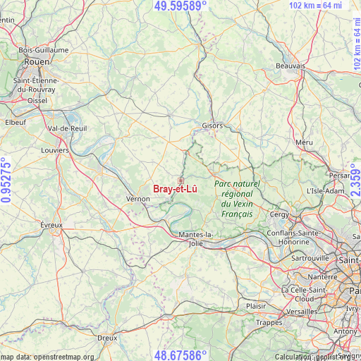
Bray-et-Lû GPS coordinates[2]
49° 8' 16.836" North, 1° 39' 21.132" East
| Map corner | latitude | longitude |
|---|---|---|
| Upper-left | 49.59589°, | 0.95275° |
| Center: | 49.13801°, | 1.65587° |
| Lower-right: | 48.67586°, | 2.359° |
| Map W x H: | 102.3×102.3 km | = 63.6×63.6mi |
| max Lat: | 51.07786° ⇑16.9% North |
| Bray-et-Lû: | 49.13801° |
| min Lat: | ⇓83.1% South 41.3874° |
| min Long | Bray-et-Lû | max Long |
| -5.08615° | 1.65587° | 9.52242° |
| W 39.1%⇐ | ⇒60.9% E |
Elevation
Elevation of Bray-et-Lû is 28 m = 92 ft, and this is 165.7 m = 544 ft below average elevation for this country.
| Max E: |
2333 m = 7654 ft | 90.7% |
| Avg. | 193.7 m = 635 ft | |
| Bray-et-Lû | 28 m = 92 ft | |
Min E: |
-1 m = -3 ft | 9.3% |
See also: France elevation on elevation.city.
Geographical zone
Bray-et-Lû is located in North temperate zone (between Tropic of Cancer and the Arctic Circle). Distance of this North polar circle is 1937.5 km =1203.9 mi to North.| Distance of | km | miles | from Bray-et-Lû |
|---|---|---|---|
| North Pole | 4543.4 | 2823.1 | to North |
| Arctic Circle | 1937.5 | 1203.9 | to North |
| Tropic Cancer | 2857.7 | 1775.7 | to South |
| Equator | 5463.6 | 3394.9 | to South |


Nearby cities:
15 places around Bray-et-Lû: (largest is in red/bold)
• Chaussy
3.1 km =1.9 mi,  124°
124°
• Château-sur-Epte
6.7 km =4.2 mi,  3°
3°
• Fourges
2.2 km =1.4 mi,  211°
211°
• Gasny
6.4 km =4 mi,  216°
216°
• Genainville
6.9 km =4.3 mi,  94°
94°
• Gommecourt
7.3 km =4.5 mi, 213°
• La Roche-Guyon
6.6 km =4.1 mi,  196°
196°
• Moisson
7.2 km =4.5 mi,  172°
172°
• Saint-Clair-sur-Epte
8 km =5 mi,  13°
13°
• Saint-Gervais
9.1 km =5.7 mi,  66°
66°
• Sainte-Geneviève-lès-Gasny
8 km =5 mi, 220°
• Tilly
9.3 km =5.8 mi,  274°
274°
• Tourny
9.4 km =5.8 mi,  301°
301°
• Vétheuil
9.1 km =5.7 mi,  157°
157°
• Écos
3.2 km =2 mi,  352°
352°
Sources, notices
• [Note1] Compared only with cities in France existing in our database
• [Src1] Map data: © OpenStreetMap contributors (CC-BY-SA)
• [Src2] Other city data from geonames.org with taken over terms of usage.
• [Src3] Geographical zone / Annual Mean Temperature by Robert A. Rohde @ Wikipedia
